IMAGES TAKEN NEAR TO
Ardcarn Drive, BELFAST, BT5 7RS
Introduction
This page details the photographs taken nearby to Ardcarn Drive, BT5 7RS by members of the Geograph project.
The Geograph project started in 2005 with the aim of publishing, organising and preserving representative images for every square kilometre of Great Britain, Ireland and the Isle of Man.

There are currently over 7.5m images from over14,400 individuals and you can help contribute to the project by visiting https://www.geograph.org.uk
Image Map
Images are licensed for reuse under creativecommons.org/licenses/by-sa/2.0
Notes
- Clicking on the map will re-center to the selected point.
- The higher the marker number, the further away the image location is from the centre of the postcode.
Image Listing (42 Images Found)
Images are licensed for reuse under creativecommons.org/licenses/by-sa/2.0
Image
Details
Distance
1
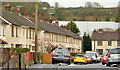
Ardcarn Drive, Belfast
Architecturally, this is a typical example of the Ardcarn estate. Rendered terraces where some houses have been sold and/or modernised.
Image: © Albert Bridge
Taken: 14 Feb 2014
0.03 miles
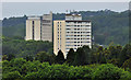
2
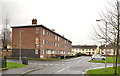
Ardcarn Green, Belfast
This view shows what might be called a “period piece” example of design in social housing back in the 1950/60’s. The Ardcarn estate was a medium-sized greenfield development which extended the existing limit of developed east Belfast. Many of the houses were rendered, there was the obligatory tower block Image and flat-roofed accommodation which can also be seen at Cregagh Image and Annadale Image
Image: © Albert Bridge
Taken: 14 Feb 2014
0.09 miles
3
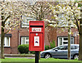
Postbox BT5 433, Ardcarn, Belfast (April 2017)
A new pressed-steel postbox (BT5 433) at Ardcarn Drive.
Image: © Albert Bridge
Taken: 28 Apr 2017
0.11 miles
4
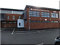
Hanwood Sports Centre
The sports centre is adjacent to a 3G football pitch.
Image: © Jude Byrne
Taken: 21 Oct 2012
0.11 miles
5
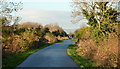
The Comber Greenway, Dundonald (4)
The Comber Greenway (built on the course the old railway line), looking towards Belfast, close to the back of here Image
Image: © Albert Bridge
Taken: 8 Jan 2014
0.13 miles
6
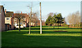
Green space, Tullycarnet, Dundonald
Large areas of green space were common features of the bigger estates of the 1960’s and 70’s. This relatively modest one is between Kinross Avenue (left) and the Comber Greenway Image
Image: © Albert Bridge
Taken: 8 Jan 2014
0.13 miles
7
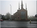
St. Molua's Stormont
Church of Ireland Parish Church seen across a misty road.
Image: © Brian Shaw
Taken: 23 Nov 2005
0.14 miles
8
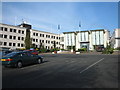
Stormont Hotel
Showing Reception and one of the wings.
Image: © Brian Shaw
Taken: 21 Nov 2005
0.14 miles
9
Carnet House, Belfast (4)
The multi-storey flats Carnet House (right) http://www.geograph.org.uk/search.php?i=32588074 and the Government offices Dundonald House Image, on the Upper Newtownards Road, seen from a height on the Ballyhanwood Road Image
Image: © Albert Bridge
Taken: 26 Jun 2012
0.15 miles
10
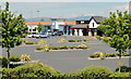
The Eastpoint Entertainment Village, Dundonald (1)
The East Point Entertainment Village, beside this roundabout Image, is anchored by an eight-screen Omniplex cinema Image It has several restaurants and parking for some 670 cars.
Image: © Albert Bridge
Taken: 5 Jun 2013
0.16 miles