1
Postbox BT5 267D, Belfast (June 2015)
Wall-mounted EIIR postbox (BT5 267D) at the Gilnahirk Road end of Moyne Park. It has now only one (morning) collection daily Monday-Saturday.
Image: © Albert Bridge
Taken: 19 Jun 2015
0.08 miles
2
Recycling bins, Gilnahirk, Belfast (January 2018)
Recycling bins, at this lay-by
Image, on the Gilnahirk Road.
Image: © Albert Bridge
Taken: 6 Jan 2018
0.13 miles
3
Castlereagh Borough Council sign, Gilnahirk, Belfast (June 2015)
A Castlereagh Borough Council “no dumping” sign at a lay-by on the Gilnahirk Road. The council amalgamated with Lisburn upon re-organisation of local government on 1 April 2015 when many boundaries changed. This area is now in the Gilnahirk ward of Belfast City Council.
Image: © Albert Bridge
Taken: 19 Jun 2015
0.13 miles
4
Gilnahirk Presbyterian church, Belfast - June 2015(2)
See
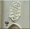
Image A plaque, giving a short architectural history of the church, above the entrance. Last seen in November 2005
Image
Image: © Albert Bridge
Taken: 19 Jun 2015
0.14 miles
5
Gilnahirk Presbyterian church, Belfast - June 2015(1)
A church at the corner of the Gilnahirk and Rocky Roads. Not listed but described in detail here http://www.doeni.gov.uk/niea/content-databases-buildview?id=17100&js=true where the description includes “A symmetrical double-height rendered neo-Gothic Presbyterian Church with two-stage entrance tower (1910); dated 1845 with later alterations; built on the site of an earlier church. Rectangular on plan with two-stage entrance tower and large modern extension to rear”. Last seen in November 2005
Image Image shows the plaque above the entrance.
Image: © Albert Bridge
Taken: 19 Jun 2015
0.14 miles
6
The Rocky Road, Gilnahirk, Belfast - June 2015(2)
See
Image The “no through road” sign (just out of picture to the left in the previous photograph).
Image: © Albert Bridge
Taken: 19 Jun 2015
0.14 miles
7
The Rocky Road, Gilnahirk, Belfast - June 2015(1)
See
Image and
Image The other Rocky Road – in this case it runs from the Gilnahirk Road (behind me) to the Upper Braniel Road but is not all public and definitely not suitable for motor vehicles.
Image shows the “no through road” sign.
Image: © Albert Bridge
Taken: 19 Jun 2015
0.14 miles
8
No 99 Gilnahirk Road, Belfast (January 2018)
A new detached house nearing completion. The agents’ description includes “Extending to c.1750 Sq Ft its accommodation comprises of a large living room, kitchen/living and dining with the added benefit of a sun room and separate utility room. On the first floor there are four well proportioned bedrooms with the master having an ensuite and dressing room. Construction will be finished early 2018.”
I have no connection with the property or the sale. I cannot enter into correspondence.
Image: © Albert Bridge
Taken: 6 Jan 2018
0.15 miles
9
Site adjacent to no 91 Gilnahirk Road, Belfast (January 2018)
A vacant site now agreed for sale. The agent’s description includes “Residential development for four apartments on the Gilnahirk Road Full planning approval granted LA04/2016/0343/F Each apartment comprises: two bedrooms, open plan kitchen dining area and a bathroom Super location within walking distance to Cherryvalley and local amenities”.
The following planning permission (19 October 2016) applies “LA04/2016/0343/F Proposed 6no. 2 bedroom apartments in 2no. 2 storey blocks with associated site works. Lands adjacent to 91 Gilnahirk Road Belfast BT5 7QL”.
Image: © Albert Bridge
Taken: 6 Jan 2018
0.17 miles
10
Drop box, Gilnahirk, Belfast (January 2018)
Royal Mail drop box on the Lower Braniel Road.
Image: © Albert Bridge
Taken: 6 Jan 2018
0.19 miles


