1
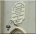
Gilnahirk Presbyterian church, Belfast - June 2015(1)
A church at the corner of the Gilnahirk and Rocky Roads. Not listed but described in detail here http://www.doeni.gov.uk/niea/content-databases-buildview?id=17100&js=true where the description includes “A symmetrical double-height rendered neo-Gothic Presbyterian Church with two-stage entrance tower (1910); dated 1845 with later alterations; built on the site of an earlier church. Rectangular on plan with two-stage entrance tower and large modern extension to rear”. Last seen in November 2005
Image Image shows the plaque above the entrance.
Image: © Albert Bridge
Taken: 19 Jun 2015
0.04 miles
2
Gilnahirk Presbyterian church, Belfast - June 2015(2)
See
Image A plaque, giving a short architectural history of the church, above the entrance. Last seen in November 2005
Image
Image: © Albert Bridge
Taken: 19 Jun 2015
0.04 miles
3
Postbox BT5 267D, Belfast (June 2015)
Wall-mounted EIIR postbox (BT5 267D) at the Gilnahirk Road end of Moyne Park. It has now only one (morning) collection daily Monday-Saturday.
Image: © Albert Bridge
Taken: 19 Jun 2015
0.05 miles
4
The Rocky Road, Gilnahirk, Belfast - June 2015(2)
See
Image The “no through road” sign (just out of picture to the left in the previous photograph).
Image: © Albert Bridge
Taken: 19 Jun 2015
0.07 miles
5
The Rocky Road, Gilnahirk, Belfast - June 2015(1)
See
Image and
Image The other Rocky Road – in this case it runs from the Gilnahirk Road (behind me) to the Upper Braniel Road but is not all public and definitely not suitable for motor vehicles.
Image shows the “no through road” sign.
Image: © Albert Bridge
Taken: 19 Jun 2015
0.07 miles
6
The Gilnahirk Road, Belfast - June 2015(1)
The view, inward, along the Gilnahirk Road as it approaches the end of built-up Belfast/the 30mph speed limit. The road on the left was, to the best of my knowledge, the original line and is now signposted as a private road.
Image: © Albert Bridge
Taken: 19 Jun 2015
0.11 miles
7
"Welcome to Gilnahirk" sign, Belfast (June 2015)
A “Welcome to Gilnahirk” sign just inside the 30mph zone on the Gilnahirk Road. The white patch was the arms of the old Castlereagh Borough Council.
Image: © Albert Bridge
Taken: 19 Jun 2015
0.15 miles
8
30 mph signs and road markings, Gilnahirk, Belfast - June 2015(2)
30 mph road markings and a “national speed limit applies” sign, on the Gilnahirk Road, at the start of built-up Belfast. This is a place where there is an abrupt change from a rural road (60 mph) to a suburban one. It also marks the current limit of development.
Image: © Albert Bridge
Taken: 19 Jun 2015
0.16 miles
9
30 mph signs and road markings, Gilnahirk, Belfast - June 2015(1)
30 mph signs and road markings, on the Gilnahirk Road, at the start of built-up Belfast. This is a place where there is an abrupt change from a rural road (60 mph) to a suburban one
Image: © Albert Bridge
Taken: 19 Jun 2015
0.16 miles
10
Road marking and rumble strips, Gilnahirk, Belfast (June 2015)
A “slow” marking and three red transverse rumble strips, on the Gilnahirk Road, approaching the start of the 30 mph zone. This is a place where there is an abrupt change from a rural road (60 mph) to a suburban one. The strips give an audible warning of the change.
Image: © Albert Bridge
Taken: 19 Jun 2015
0.20 miles


