IMAGES TAKEN NEAR TO
Woodcroft Heights, BELFAST, BT5 7NX
Introduction
This page details the photographs taken nearby to Woodcroft Heights, BT5 7NX by members of the Geograph project.
The Geograph project started in 2005 with the aim of publishing, organising and preserving representative images for every square kilometre of Great Britain, Ireland and the Isle of Man.

There are currently over 7.5m images from over14,400 individuals and you can help contribute to the project by visiting https://www.geograph.org.uk
Image Map
Images are licensed for reuse under creativecommons.org/licenses/by-sa/2.0
Notes
- Clicking on the map will re-center to the selected point.
- The higher the marker number, the further away the image location is from the centre of the postcode.
Image Listing (2 Images Found)
Images are licensed for reuse under creativecommons.org/licenses/by-sa/2.0
Image
Details
Distance
1
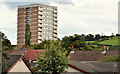
Whincroft House, Belfast
Whincroft House is a 15 storey block of flats in The Braniel. Similar to the two at Finaghy http://www.geograph.org.uk/search.php?i=24002128. The view is from the Knock Road.
Image: © Albert Bridge
Taken: 15 Aug 2011
0.23 miles
2
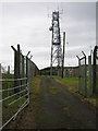
Radio Mast
On the upper slopes of Braniel Hill. The gates are open because a maintenance crew arrived at the same time as me. Looking north.
Image: © Brian Shaw
Taken: 18 Jan 2006
0.25 miles