IMAGES TAKEN NEAR TO
Summerhill Park, BELFAST, BT5 7HE
Introduction
This page details the photographs taken nearby to Summerhill Park, BT5 7HE by members of the Geograph project.
The Geograph project started in 2005 with the aim of publishing, organising and preserving representative images for every square kilometre of Great Britain, Ireland and the Isle of Man.

There are currently over 7.5m images from over14,400 individuals and you can help contribute to the project by visiting https://www.geograph.org.uk
Image Map
Images are licensed for reuse under creativecommons.org/licenses/by-sa/2.0
Notes
- Clicking on the map will re-center to the selected point.
- The higher the marker number, the further away the image location is from the centre of the postcode.
Image Listing (47 Images Found)
Images are licensed for reuse under creativecommons.org/licenses/by-sa/2.0
Image
Details
Distance
1
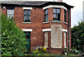
613 Upper Newtownards Road, Belfast
Vacant and partly boarded-up semi, at the corner of Stormont Court, awaiting redevelopment.
Image: © Albert Bridge
Taken: 2 Aug 2011
0.07 miles
2
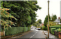
Barnett's Road, Belfast (2)
See Image Close to the eastern end of the road – the view from the corner of Castleview Cottage Gardens where there is a good crop of rowan barriers (left).
Image: © Albert Bridge
Taken: 10 Oct 2011
0.07 miles
3
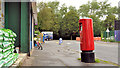
Pillar box, Belfast
Leaning EIIR pillar box, at the Upper Newtownards Road end of Summerhill Avenue.
Image: © Albert Bridge
Taken: 2 Aug 2011
0.08 miles
4
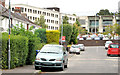
Summerhill Parade, Belfast
A short street, on the northern side of Barnett’s Road, close to the Stormont Hotel Image (background).
Image: © Albert Bridge
Taken: 29 Aug 2013
0.08 miles
5
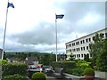
Gardens of Stormont Hotel
Viewed from the main entrance.
Image: © James Allan
Taken: 2 Jul 2012
0.08 miles
6
The La Scala Restaurant at the Stormont Hotel, Belfast
Located opposite the main gates of Stormont - Northern Ireland's Legislative Assembly - La Scala is regarded as one of Belfast's top restaurants.
Image: © Eric Jones
Taken: 26 Jun 2017
0.10 miles
7
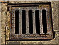
Grating cover, Stormont, Belfast
A grating cover, on the Upper Newtownards Road, close to Image No maker’s name shown but the bottom right has the letters “N.I.FIU.R”.
Image: © Albert Bridge
Taken: 2 Aug 2011
0.10 miles
8
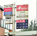
Summerhill bus stop, Belfast - November 2014(2)
The sign at this bus stop Image
Image: © Albert Bridge
Taken: 26 Nov 2014
0.11 miles
9
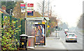
Summerhill bus stop, Belfast - November 2014(1)
The inward bus stop, on the Upper Newtownards Road, between St Molua’s church Image and Summerhill Avenue Image Used by Metro services and inward Ulsterbus 500 buses. There is, at present, no bus lane or other bus-priority measures.
Image: © Albert Bridge
Taken: 26 Nov 2014
0.11 miles
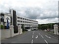
10
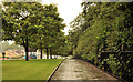
Footpath and trees, Stormont, Belfast (2)
The footpath, on the Upper Newtownards Road, on the eastern side of Stormont gates Image, well sheltered by a line of mature trees. The Stormont estate is behind the railings (right).
Image: © Albert Bridge
Taken: 2 Aug 2011
0.11 miles