IMAGES TAKEN NEAR TO
Kings Road, BELFAST, BT5 7EG
Introduction
This page details the photographs taken nearby to Kings Road, BT5 7EG by members of the Geograph project.
The Geograph project started in 2005 with the aim of publishing, organising and preserving representative images for every square kilometre of Great Britain, Ireland and the Isle of Man.

There are currently over 7.5m images from over14,400 individuals and you can help contribute to the project by visiting https://www.geograph.org.uk
Image Map
Images are licensed for reuse under creativecommons.org/licenses/by-sa/2.0
Notes
- Clicking on the map will re-center to the selected point.
- The higher the marker number, the further away the image location is from the centre of the postcode.
Image Listing (36 Images Found)
Images are licensed for reuse under creativecommons.org/licenses/by-sa/2.0
Image
Details
Distance
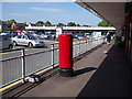
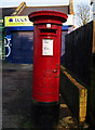
1

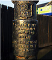
Postbox, Belfast
Detail of the 'K' series postbox seen in Image at the King's Square shopping complex in east Belfast. The plaque on the back reads:
"One of the first
castings of the
1980 'K' pillar box".
The box was cast by the Lion Foundry of Kirkintilloch.
Image: © Rossographer
Taken: 4 Jun 2010
0.08 miles
2
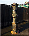
Postbox, Belfast
Elizabeth II 'K' series postbox in the King's Square shopping complex off the King's Road in east Belfast. This box was one of the first 'K' series to be cast - see Image
Image: © Rossographer
Taken: 4 Jun 2010
0.08 miles
3
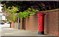
Pillar box BT5 415, Belfast
GVIR pillar box (BT5 415) on the King’s Road.
Image: © Albert Bridge
Taken: 25 Apr 2014
0.11 miles
4
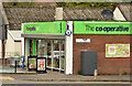
Co-op, Belfast (April 2014)
Standard Co-op on the King’s Road, at the corner of King’s Square.
Image: © Albert Bridge
Taken: 25 Apr 2014
0.12 miles
5
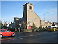
Stormont Presbyterian Church
The Congregation was formed in 1932.
Image: © Brian Shaw
Taken: 21 Nov 2005
0.12 miles
6
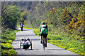
Comber Greenway
Cyclists on the greenway. On the left is what I assume to be a disabled cyclist on a hand-cranked recumbent tricycle. They passed me,on my Brompton folding bike, at a fair pace.
Image: © Robert Ashby
Taken: 22 Apr 2015
0.15 miles
7
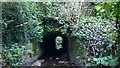
BCDR third culvert over Knock River (downstream end)
BCDR third culvert over Knock River (downstream end)
The Belfast and County Down Railway track between Belfast and Comber, now the Comber Greenway, required three culverts to maintain the flow of the Knock River. This is the downstream end of the third culvert.
Image: © Alan Collins
Taken: 11 Dec 2013
0.15 miles
8
Boundary Post, Belfast
Detail of the old Belfast boundary post on the Gilnahirk Road Image seen in Image
The inscription reads
"Parliamentary
and Municipal Boundary of
Belfast
Pottinger Division
Pottinger Ward
1918".
Image: © Rossographer
Taken: 15 Mar 2011
0.15 miles
9
Boundary Post, Belfast
Old Belfast boundary post on the Gilnahirk Road Image
The inscription reads
"Parliamentary
and Municipal Boundary of
Belfast
Pottinger Division
Pottinger Ward
1918".
Image: © Rossographer
Taken: 15 Mar 2011
0.15 miles
10
Postbox, Belfast
George V postbox on the Gilnahirk Road in Belfast Image
Image: © Rossographer
Taken: 15 Mar 2011
0.15 miles