IMAGES TAKEN NEAR TO
Gilnahirk Road, BELFAST, BT5 7DG
Introduction
This page details the photographs taken nearby to Gilnahirk Road, BT5 7DG by members of the Geograph project.
The Geograph project started in 2005 with the aim of publishing, organising and preserving representative images for every square kilometre of Great Britain, Ireland and the Isle of Man.

There are currently over 7.5m images from over14,400 individuals and you can help contribute to the project by visiting https://www.geograph.org.uk
Image Map
Images are licensed for reuse under creativecommons.org/licenses/by-sa/2.0
Notes
- Clicking on the map will re-center to the selected point.
- The higher the marker number, the further away the image location is from the centre of the postcode.
Image Listing (49 Images Found)
Images are licensed for reuse under creativecommons.org/licenses/by-sa/2.0
Image
Details
Distance
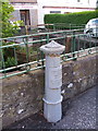
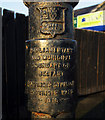
1
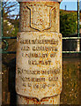
Boundary Post, Belfast
Detail of the post seen in Image on the Gilnahirk Road Image
The inscription reads
"Parliamentary
and Municipal Boundary of
Belfast
Pottinger Division
Pottinger Ward
1918".
Image: © Rossographer
Taken: 15 Mar 2011
0.02 miles
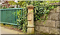
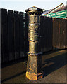
2
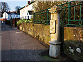
Boundary Post, Belfast
Old Belfast boundary post on the Gilnahirk Road Image
The inscription reads
"Parliamentary
and Municipal Boundary of
Belfast
Pottinger Division
Pottinger Ward
1918".
Image: © Rossographer
Taken: 15 Mar 2011
0.02 miles
3
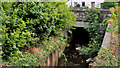
The Knock River, Belfast (8)
See Image The view in the opposite direction with the Gilnahirk Road bridge in the background. Image shows the view downstream.
Image: © Albert Bridge
Taken: 5 Sep 2011
0.02 miles
4
Old boundary post, King's Road, Belfast - April 2014 (2)
See Image The inscription “PARLIAMENTARY AND MUNICIPAL BOUNDARY OF BELFAST POTTINGER DIVISION POTTINGER WARD 1918”. To the best of my knowledge many boundaries were changed in 1918 with the passing of The Representation of the People Act http://en.wikipedia.org/wiki/Representation_of_the_People_Act_1918.
Image: © Albert Bridge
Taken: 25 Apr 2014
0.02 miles
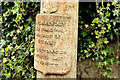
5
Old boundary post, King's Road, Belfast - April 2014 (1)
See Image (July 2008), Image and Image (both March 2011). This must be one of the few places, in Belfast, where there are several old boundary posts within a minute of each other. This one, also close to the Knock River, is on the King’s Road near the corner of the Gilnahirk Road. Image shows the inscription.
Image: © Albert Bridge
Taken: 25 Apr 2014
0.02 miles
6
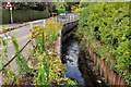
The Knock River, Belfast (7)
See Image The Knock River, looking downstream, from the bridge on the Gilnahirk Road. Cherryvalley is on the left. Image shows the view towards the bridge. Subsequent photographs of the river may be seen by clicking on the Knock River shared description title (below).
Image: © Albert Bridge
Taken: 5 Sep 2011
0.03 miles
7
Belfast Boundary marker at Knock river bridge, Cherryvalley
Plate reads:
Parliamentary and Municipal Boundary of Belfast
Pottinger Division
Pottinger Ward
--1918--
Image: © Chris Burrell
Taken: 2 Jul 2008
0.03 miles
8
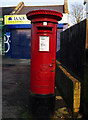
Postbox, Belfast
George V postbox on the Gilnahirk Road in Belfast Image
Image: © Rossographer
Taken: 15 Mar 2011
0.04 miles
9
Boundary Post, Belfast
Old Belfast boundary post on the Gilnahirk Road Image
The inscription reads
"Parliamentary
and Municipal Boundary of
Belfast
Pottinger Division
Pottinger Ward
1918".
Image: © Rossographer
Taken: 15 Mar 2011
0.04 miles
10
Boundary Post, Belfast
Detail of the old Belfast boundary post on the Gilnahirk Road Image seen in Image
The inscription reads
"Parliamentary
and Municipal Boundary of
Belfast
Pottinger Division
Pottinger Ward
1918".
Image: © Rossographer
Taken: 15 Mar 2011
0.04 miles