IMAGES TAKEN NEAR TO
Moycraig Road, BUSHMILLS, BT57 8YB
Introduction
This page details the photographs taken nearby to Moycraig Road, BT57 8YB by members of the Geograph project.
The Geograph project started in 2005 with the aim of publishing, organising and preserving representative images for every square kilometre of Great Britain, Ireland and the Isle of Man.

There are currently over 7.5m images from over14,400 individuals and you can help contribute to the project by visiting https://www.geograph.org.uk
Image Map
Images are licensed for reuse under creativecommons.org/licenses/by-sa/2.0
Notes
- Clicking on the map will re-center to the selected point.
- The higher the marker number, the further away the image location is from the centre of the postcode.
Image Listing (3 Images Found)
Images are licensed for reuse under creativecommons.org/licenses/by-sa/2.0
Image
Details
Distance
1
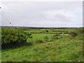
Croachmore Townland
Some rough pasture land.
Image: © Kenneth Allen
Taken: 15 Aug 2007
0.05 miles
2
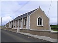
Croaghmore Presbyterian Church
It is located to the east of Bushmills.
Image: © Kenneth Allen
Taken: 15 Aug 2007
0.06 miles
3
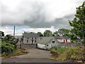
Disused farm
Farm buildings and house which is now boarded up
Image: © Mat Tuck
Taken: 3 Jun 2014
0.10 miles