IMAGES TAKEN NEAR TO
Strawbridge Park, BUSHMILLS, BT57 8XG
Introduction
This page details the photographs taken nearby to Strawbridge Park, BT57 8XG by members of the Geograph project.
The Geograph project started in 2005 with the aim of publishing, organising and preserving representative images for every square kilometre of Great Britain, Ireland and the Isle of Man.

There are currently over 7.5m images from over14,400 individuals and you can help contribute to the project by visiting https://www.geograph.org.uk
Image Map
Images are licensed for reuse under creativecommons.org/licenses/by-sa/2.0
Notes
- Clicking on the map will re-center to the selected point.
- The higher the marker number, the further away the image location is from the centre of the postcode.
Image Listing (6 Images Found)
Images are licensed for reuse under creativecommons.org/licenses/by-sa/2.0
Image
Details
Distance
1
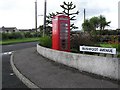
Bushfoot Avenue, Port Ballintrea
Smoeone has an old phone box as a feature in their garden.
Image: © Kenneth Allen
Taken: 19 Aug 2006
0.09 miles
2
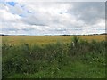
Barley, Portballintrae
Fields between the tramway and village.
Image: © Richard Webb
Taken: 4 Aug 2013
0.17 miles
3
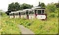
Train near Bushmills (3)
The 13.30 from Bushmills, beside the public path, on the Causeway side of this level crossing Image
Image: © Albert Bridge
Taken: 2 Sep 2012
0.20 miles
4
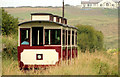
Train near Bushmills (4)
The 13.30 from Bushmills as it heads towards the Causeway. The clubhouse of Bushfoot Golf Club http://www.bushfootgolfclub.co.uk/ is at top right.
Image: © Albert Bridge
Taken: 2 Sep 2012
0.22 miles
5
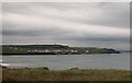
Portballintrae from the north
Portballintrae (in Irish Port Bhaile an Trá meaning "port of town on the beach") is a fashionable resort which developed during the twentieth century for a street of fishermen's cottages. It lies within the Coleraine Borough Council area.
Image: © Eric Jones
Taken: 25 Sep 2013
0.24 miles
6
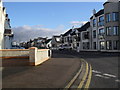
Ballaghmore Road, Portballintrae
Leading towards Bushmills.
Image: © Dean Molyneaux
Taken: 27 Feb 2010
0.24 miles