IMAGES TAKEN NEAR TO
Craigaboney Road, BUSHMILLS, BT57 8XD
Introduction
This page details the photographs taken nearby to Craigaboney Road, BT57 8XD by members of the Geograph project.
The Geograph project started in 2005 with the aim of publishing, organising and preserving representative images for every square kilometre of Great Britain, Ireland and the Isle of Man.

There are currently over 7.5m images from over14,400 individuals and you can help contribute to the project by visiting https://www.geograph.org.uk
Image Map
Images are licensed for reuse under creativecommons.org/licenses/by-sa/2.0
Notes
- Clicking on the map will re-center to the selected point.
- The higher the marker number, the further away the image location is from the centre of the postcode.
Image Listing (2 Images Found)
Images are licensed for reuse under creativecommons.org/licenses/by-sa/2.0
Image
Details
Distance
1
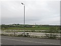
The countryside south-west of Bushmills
The enclosed area in the foreground is the car park of the disused Dunluce Presbyterian Church.
Image: © Eric Jones
Taken: 26 Sep 2013
0.23 miles
2
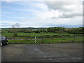
Ballyness townland
Looking towards Bushmills from the car-park at Bushmills garden centre.
Image: © Willie Duffin
Taken: 21 May 2009
0.23 miles