IMAGES TAKEN NEAR TO
Ballyclogh Road, BUSHMILLS, BT57 8TU
Introduction
This page details the photographs taken nearby to Ballyclogh Road, BT57 8TU by members of the Geograph project.
The Geograph project started in 2005 with the aim of publishing, organising and preserving representative images for every square kilometre of Great Britain, Ireland and the Isle of Man.

There are currently over 7.5m images from over14,400 individuals and you can help contribute to the project by visiting https://www.geograph.org.uk
Image Map
Images are licensed for reuse under creativecommons.org/licenses/by-sa/2.0
Notes
- Clicking on the map will re-center to the selected point.
- The higher the marker number, the further away the image location is from the centre of the postcode.
Image Listing (6 Images Found)
Images are licensed for reuse under creativecommons.org/licenses/by-sa/2.0
Image
Details
Distance
1
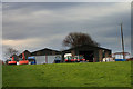
Ballyclogh Road(3)
Farm buildings and assorted machinery near Ballybogy.
Image: © Robert Ashby
Taken: 20 Dec 2017
0.00 miles
2
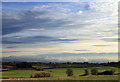
Near Ballybogy
Looking west towards the distant Sperrins under a nice midwinter sky.
Image: © Robert Ashby
Taken: 20 Dec 2017
0.11 miles
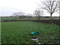
3
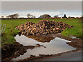
A moment of reflection
A pile of rubble reflected in a large muddy pool of water block the entrance to this field beside the Ballyclough Road..
Image: © Robert Ashby
Taken: 20 Dec 2017
0.13 miles
4
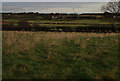
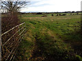
Ballyclogh Road (1)
Looking NE across rough pasture.
Image: © Robert Ashby
Taken: 20 Dec 2017
0.23 miles
5
Ballyclogh Road (2)
Looking east towards the River Bush.
Image: © Robert Ashby
Taken: 20 Dec 2017
0.23 miles
6
Ballyleckan Townland
Looking eastwards to Deepstown
Image: © Kenneth Allen
Taken: 1 Feb 2008
0.24 miles