IMAGES TAKEN NEAR TO
Burn Brae, BUSHMILLS, BT57 8TL
Introduction
This page details the photographs taken nearby to Burn Brae, BT57 8TL by members of the Geograph project.
The Geograph project started in 2005 with the aim of publishing, organising and preserving representative images for every square kilometre of Great Britain, Ireland and the Isle of Man.

There are currently over 7.5m images from over14,400 individuals and you can help contribute to the project by visiting https://www.geograph.org.uk
Image Map
Images are licensed for reuse under creativecommons.org/licenses/by-sa/2.0
Notes
- Clicking on the map will re-center to the selected point.
- The higher the marker number, the further away the image location is from the centre of the postcode.
Image Listing (6 Images Found)
Images are licensed for reuse under creativecommons.org/licenses/by-sa/2.0
Image
Details
Distance
1
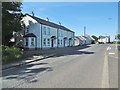
Lisnagunogue, cottages
On Whitepark Road (A2). The hamlet comprises perhaps twenty cottages, a small development of bungalows, a public house and a church.
Image: © Mike Faherty
Taken: 27 Jun 2018
0.03 miles
2
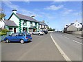
Whitepark Road
Looking ENE, included in the frame is the Causeway Tavern
Image: © Kenneth Allen
Taken: 1 Jun 2013
0.03 miles
3
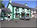
McBride's Bar
It is located at Lisnagunogue.
Image: © Kenneth Allen
Taken: 17 Aug 2006
0.04 miles
4
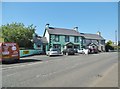
Lisnagunogue, Causeway Tavern
On Whitepark Road (A2); aka McBrides Bar. Counter back left, drinking area front and back; pool, games machine. The pub also has accommodation. Craic can be assured if locals are present.
Image: © Mike Faherty
Taken: 27 Jun 2018
0.06 miles
5
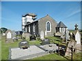
Dunseverick Parish Church
Actually on the outskirts of Lisnagunogue, on A2 (Whitepark Road). Built in 1831, and currently being renovated. http://www.ballintoy.connor.anglican.org/dunseverickchurch.html
Image: © Mike Faherty
Taken: 27 Jun 2018
0.18 miles
6
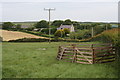
Lisnagunogue
Fields just north of Lisnagunogue.
Image: © Anne Burgess
Taken: 2 Jun 2007
0.20 miles