IMAGES TAKEN NEAR TO
Priestland Road, BUSHMILLS, BT57 8QP
Introduction
This page details the photographs taken nearby to Priestland Road, BT57 8QP by members of the Geograph project.
The Geograph project started in 2005 with the aim of publishing, organising and preserving representative images for every square kilometre of Great Britain, Ireland and the Isle of Man.

There are currently over 7.5m images from over14,400 individuals and you can help contribute to the project by visiting https://www.geograph.org.uk
Image Map
Images are licensed for reuse under creativecommons.org/licenses/by-sa/2.0
Notes
- Clicking on the map will re-center to the selected point.
- The higher the marker number, the further away the image location is from the centre of the postcode.
Image Listing (353 Images Found)
Images are licensed for reuse under creativecommons.org/licenses/by-sa/2.0
Image
Details
Distance
1
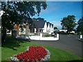
Dunluce Parish Centre, Priestland Road, Bushmills
This is the parish centre of the Anglican Dunluce Parish. This centre has recently been refurbished.
http://www.canavans-qs.com/portfolio/dunluce-parish-church-hall/
Image: © Eric Jones
Taken: 9 Aug 2011
0.00 miles
2
Dunluce Parish Centre, Priestland Road, Bushmills
This is the parish centre of the Anglican Dunluce Parish. This centre has recently been refurbished.
http://www.canavans-qs.com/portfolio/dunluce-parish-church-hall/
Image: © Eric Jones
Taken: 24 Sep 2013
0.01 miles
3
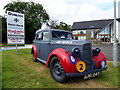
RAF car, Bushmills
Pictured at the Parish Centre Exhibition
Image: © Kenneth Allen
Taken: 19 Jul 2018
0.02 miles
4
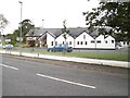
The Gospel Hall, Priestland Road, Bushmills
The tower of Dunluce Parish Church (Church of Ireland) can be seen in the background.
Image: © Eric Jones
Taken: 24 Sep 2013
0.03 miles
5
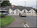
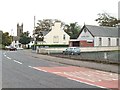
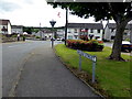
The junction of Bridge Street and Priestland Road at Bushmills
The building in the background is the newly refurbished Dunluce CoI Parish Centre. The bus is a school service.
Image: © Eric Jones
Taken: 26 Sep 2013
0.03 miles
6
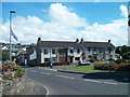
The junction of Bridge Street and Priestland Road, Bushmills
The houses are in Church Street.
Image: © Eric Jones
Taken: 9 Aug 2011
0.04 miles
7
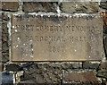
Plaque, Montgomery Memorial Parochial Hall
No sign of the building but the plaque is pictured here Image]
Image: © Kenneth Allen
Taken: 19 Jul 2018
0.04 miles
8
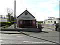
Gospel Hall, Bushmills
Pictured along Priestland Road
Image: © Kenneth Allen
Taken: 26 Apr 2016
0.05 miles
9
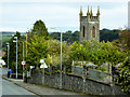
Priestlands Road, Dunluce Parish Church Tower
The parish church of Dunluce, St John the Baptist, stands on the ancient ecclesiastical site of Portcamman first recorded in 1262. The present building, consisting of a tower with a rectangular shaped nave attached, was completed in 1821. In 1874 the Chancel was attached and the North Transept was added in 1897 http://www.bushmillsvillage.com/stjohnthebaptist.html (bushmillsvillage.com).
Image: © David Dixon
Taken: 28 Sep 2017
0.05 miles
10
Bridge Street, Bushmills
Heading ENE from Priestland Road
Image: © Kenneth Allen
Taken: 19 Jul 2018
0.05 miles