IMAGES TAKEN NEAR TO
Haughey's Row, Castlecat Road, BUSHMILLS, BT57 8AP
Introduction
This page details the photographs taken nearby to Haughey's Row, Castlecat Road, BT57 8AP by members of the Geograph project.
The Geograph project started in 2005 with the aim of publishing, organising and preserving representative images for every square kilometre of Great Britain, Ireland and the Isle of Man.

There are currently over 7.5m images from over14,400 individuals and you can help contribute to the project by visiting https://www.geograph.org.uk
Image Map
Images are licensed for reuse under creativecommons.org/licenses/by-sa/2.0
Notes
- Clicking on the map will re-center to the selected point.
- The higher the marker number, the further away the image location is from the centre of the postcode.
Image Listing (7 Images Found)
Images are licensed for reuse under creativecommons.org/licenses/by-sa/2.0
Image
Details
Distance
1
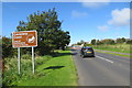
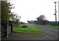
Castlecat Road
Approaching Bushmills and the Causeway Coast.
Image: © Robert Ashby
Taken: 18 Sep 2015
0.02 miles
2
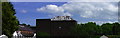
Old Bushmills Distillery, County Antrim
Image: © Chris Burrell
Taken: 6 Jun 2008
0.11 miles
3
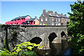
Building in progress on the eastern banks of the Bush.
The water that put the Bush in Bushmills. Mine's a double!
Image: © Des Colhoun
Taken: 8 May 2007
0.16 miles

5
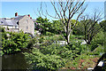
The weir on the River Bush by the salmon hatchery.
Image: © Des Colhoun
Taken: 8 May 2007
0.21 miles
7
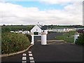
Castlecat Road, Bushmills
This image was taken from the entrance to the Ballyness Caravan Park.
Image: © Eric Jones
Taken: 23 Sep 2013
0.24 miles