IMAGES TAKEN NEAR TO
Shandon Park, BELFAST, BT5 6NX
Introduction
This page details the photographs taken nearby to Shandon Park, BT5 6NX by members of the Geograph project.
The Geograph project started in 2005 with the aim of publishing, organising and preserving representative images for every square kilometre of Great Britain, Ireland and the Isle of Man.

There are currently over 7.5m images from over14,400 individuals and you can help contribute to the project by visiting https://www.geograph.org.uk
Image Map
Images are licensed for reuse under creativecommons.org/licenses/by-sa/2.0
Notes
- Clicking on the map will re-center to the selected point.
- The higher the marker number, the further away the image location is from the centre of the postcode.
Image Listing (10 Images Found)
Images are licensed for reuse under creativecommons.org/licenses/by-sa/2.0
Image
Details
Distance
1
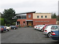
The Clubhouse
The Clubhouse at Shandon Park Golf Club.
Image: © Brian Shaw
Taken: 18 Jan 2006
0.16 miles
2
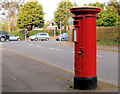
Pillar box, Belfast
EIIR pillar box, in Shandon Park near the Knock Road (background).
Image: © Albert Bridge
Taken: 1 Apr 2011
0.18 miles
3
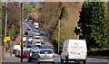
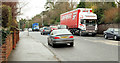
The Knock Road. Belfast (3)
See Image The view, from near Knockmount Park, along the four-lane stretch of the Knock Road, down towards the Sandown Road. Continue to Image
Image: © Albert Bridge
Taken: 1 Apr 2011
0.19 miles
4
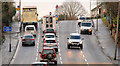
The Knock Road, Belfast (1)
The Knock Road, south of the Sandown Road lights, on the approach to the start of the dual carriageway. Continue to Image
Image: © Albert Bridge
Taken: 18 Jan 2010
0.20 miles
5
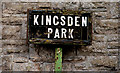
Kingsden Park sign, Belfast
Tiled sign, with the old postal district number painted on the post, at the Knock Road end of Kingsden Park.
Image: © Albert Bridge
Taken: 1 Apr 2011
0.20 miles
6
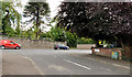
The Knock Road, Belfast (15)
The Knock Road at Knockvale Park.
Image: © Albert Bridge
Taken: 15 Aug 2011
0.20 miles
7
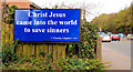
Biblical poster, Belfast
Quotation alongside the Knock dual carriageway.
Image: © Albert Bridge
Taken: 1 Apr 2011
0.23 miles
8
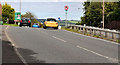
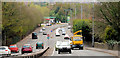
The Knock Road, Belfast (16)
The inward carriageway of the Knock Road, approaching the crest before the end of the present stretch of dual carriageway.
Image: © Albert Bridge
Taken: 15 Aug 2011
0.24 miles
9
The Knock Road, Belfast (2)
Image: © Albert Bridge
Taken: 18 Jan 2010
0.24 miles
10
The Knock Road, Belfast (4)
See Image The view, from near Knockmount Park, towards the Glen Road and The Braniel. My understanding that is that this stretch of existing dual carriageway (with what seems to be narrower than usual lanes) will also be widened with better provision for traffic turning right. Continue to Image
Image: © Albert Bridge
Taken: 1 Apr 2011
0.25 miles