IMAGES TAKEN NEAR TO
Knock Road, BELFAST, BT5 6LE
Introduction
This page details the photographs taken nearby to Knock Road, BT5 6LE by members of the Geograph project.
The Geograph project started in 2005 with the aim of publishing, organising and preserving representative images for every square kilometre of Great Britain, Ireland and the Isle of Man.

There are currently over 7.5m images from over14,400 individuals and you can help contribute to the project by visiting https://www.geograph.org.uk
Image Map
Images are licensed for reuse under creativecommons.org/licenses/by-sa/2.0
Notes
- Clicking on the map will re-center to the selected point.
- The higher the marker number, the further away the image location is from the centre of the postcode.
Image Listing (57 Images Found)
Images are licensed for reuse under creativecommons.org/licenses/by-sa/2.0
Image
Details
Distance
1
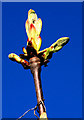
Chestnut buds, Belfast
Horse chestnut buds, about to open into leaves, beside the Knock Road.
Image: © Albert Bridge
Taken: 8 Apr 2011
0.05 miles
2
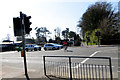
Comber Greenway
Cyclist crossing the Knock Road at the signalled crossing. The buildings in the background to the left are part of the PSNI Headquarters.
Image: © Robert Ashby
Taken: 22 Apr 2015
0.05 miles
3
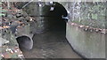
BCDR second culvert over Knock River (downstream end)
The Belfast and County Down Railway track between Belfast and Comber, now the Comber Greenway, required three culverts to maintain the flow of the Knock River. This is the downstream end of the second culvert.
Image: © Alan Collins
Taken: 5 Nov 2013
0.05 miles
4
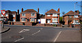
The Knock Road, Belfast (11)
The Knock Road passing the end of Cherryvalley.
Image: © Albert Bridge
Taken: 8 Apr 2011
0.06 miles
5
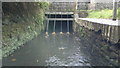
BCDR second culvert over Knock River (upstream end)
The Belfast and County Down Railway track between Belfast and Comber, now the Comber Greenway, required three culverts to maintain the flow of the Knock River. This is the upstream end of the second culvert.
Image: © Alan Collins
Taken: 5 Nov 2013
0.06 miles
6
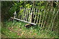
Former Knock station, Belfast (2008-2)
See Image The platform includes this fence and seat although I doubt whether they are ex-BCDR.
Image: © Albert Bridge
Taken: 30 Mar 2008
0.06 miles
7
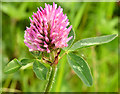
Red clover, Comber Greenway, Belfast (May 2014)
One of the most widespread of wildflowers, red clover http://www.habitas.org.uk/flora/species.asp?item=3231 , growing on the Comber Greenway, close to the Knock Road.
Image: © Albert Bridge
Taken: 13 May 2014
0.07 miles
8
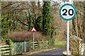
Green-bordered speed limit sign, Belfast (February 2015)
A green-bordered 20 mph speed limit sign at the Knock Road end of Cherryvalley Image My layman’s understanding is that the limit is advisory, as a traffic-calming/safety measure (used here with road humps) without a statutory basis. On the other hand . . . I can’t help thinking that, in the event of an accident, the insurance companies and police would be obliged to take failure to observe into account when assessing liability. See also Image
Image: © Albert Bridge
Taken: 20 Feb 2015
0.07 miles
9
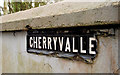
Cherryvalley sign, Belfast
The sign, with the “Y” missing at the Knock Road end of Cherryvalley. For those not too familiar with the area “Cherryvalley” exists. “Cheervelley” was a product of James Young’s Image imagination (and Billy Simpson’s too).
Image: © Albert Bridge
Taken: 1 Apr 2011
0.08 miles
10
Former Knock station, Belfast (2008-1)
See Image Knock was the next station after Neill’s Hill. The down platform still survives (on the eastern side of the Knock Road which the line crossed by a level crossing) although well covered by vegetation. The view is towards Comber. The path on the right is the Comber Greenway Image built on what was a double-track railway. See Image for a view of the platform in May 2013.
Image: © Albert Bridge
Taken: 30 Mar 2008
0.08 miles