IMAGES TAKEN NEAR TO
Knock Road, BELFAST, BT5 6LB
Introduction
This page details the photographs taken nearby to Knock Road, BT5 6LB by members of the Geograph project.
The Geograph project started in 2005 with the aim of publishing, organising and preserving representative images for every square kilometre of Great Britain, Ireland and the Isle of Man.

There are currently over 7.5m images from over14,400 individuals and you can help contribute to the project by visiting https://www.geograph.org.uk
Image Map
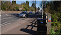
Images are licensed for reuse under creativecommons.org/licenses/by-sa/2.0
Notes
- Clicking on the map will re-center to the selected point.
- The higher the marker number, the further away the image location is from the centre of the postcode.
Image Listing (91 Images Found)
Images are licensed for reuse under creativecommons.org/licenses/by-sa/2.0
Image
Details
Distance
1
The Knock Road, Belfast (10)
The Knock Road, at the entrance to the Comber Greenway (Knock Nature Walk on the Google map), looking towards the King’s Road Image and the Upper Newtownards Road.
Image: © Albert Bridge
Taken: 8 Apr 2011
0.04 miles
2
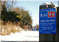
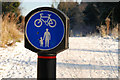
National cycle network sign, Belfast (2)
See Image At the entrance to the snow-covered Comber Greenway Image, on the Knock Road (Comber side). Continue to Image
Image: © Albert Bridge
Taken: 8 Jan 2010
0.04 miles
3
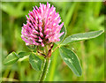
Red clover, Comber Greenway, Belfast (May 2014)
One of the most widespread of wildflowers, red clover http://www.habitas.org.uk/flora/species.asp?item=3231 , growing on the Comber Greenway, close to the Knock Road.
Image: © Albert Bridge
Taken: 13 May 2014
0.04 miles
4
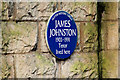
James Johnston plaque, Belfast
A plaque, on the boundary wall of a house on the Knock Road, commemorating the tenor James Johnston http://www.ulsterhistory.co.uk/johnston.htm. Its position makes it accessible to the public without disturbing the privacy of the residents.
Image: © Albert Bridge
Taken: 18 Jan 2010
0.04 miles
5
Comber Greenway sign, Belfast
At the entrance to the snow-covered Comber Greenway Image, on the Knock Road (Comber side).
Image: © Albert Bridge
Taken: 8 Jan 2010
0.04 miles
6
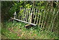
Former Knock station, Belfast (2008-2)
See Image The platform includes this fence and seat although I doubt whether they are ex-BCDR.
Image: © Albert Bridge
Taken: 30 Mar 2008
0.05 miles
7
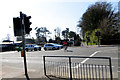
Comber Greenway
Cyclist crossing the Knock Road at the signalled crossing. The buildings in the background to the left are part of the PSNI Headquarters.
Image: © Robert Ashby
Taken: 22 Apr 2015
0.05 miles
8
Former Knock station, Belfast (2008-1)
See Image Knock was the next station after Neill’s Hill. The down platform still survives (on the eastern side of the Knock Road which the line crossed by a level crossing) although well covered by vegetation. The view is towards Comber. The path on the right is the Comber Greenway Image built on what was a double-track railway. See Image for a view of the platform in May 2013.
Image: © Albert Bridge
Taken: 30 Mar 2008
0.06 miles
9
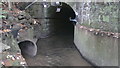
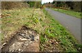
BCDR second culvert over Knock River (downstream end)
The Belfast and County Down Railway track between Belfast and Comber, now the Comber Greenway, required three culverts to maintain the flow of the Knock River. This is the downstream end of the second culvert.
Image: © Alan Collins
Taken: 5 Nov 2013
0.06 miles
10
Former Knock railway station, Belfast (February 2015)
As time progresses the remains of Knock station’s down platform (middle left) become harder to identify under a coating of vegetation. For comparison see Image (March 2008).
Image: © Albert Bridge
Taken: 20 Feb 2015
0.07 miles