IMAGES TAKEN NEAR TO
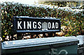
Kings Road, BELFAST, BT5 6JN
Introduction
This page details the photographs taken nearby to Kings Road, BT5 6JN by members of the Geograph project.
The Geograph project started in 2005 with the aim of publishing, organising and preserving representative images for every square kilometre of Great Britain, Ireland and the Isle of Man.

There are currently over 7.5m images from over14,400 individuals and you can help contribute to the project by visiting https://www.geograph.org.uk
Image Map
Images are licensed for reuse under creativecommons.org/licenses/by-sa/2.0
Notes
- Clicking on the map will re-center to the selected point.
- The higher the marker number, the further away the image location is from the centre of the postcode.
Image Listing (126 Images Found)
Images are licensed for reuse under creativecommons.org/licenses/by-sa/2.0
Image
Details
Distance
1
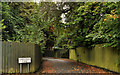
King's Park Lane, Belfast
Discretely hidden suburban thoroughfare, off the King’s Road.
Image: © Albert Bridge
Taken: 5 Sep 2011
0.06 miles
2
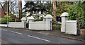
Suburban gate pillars, Belfast
Impressive matching pillars, at the entrances to two suburban houses, at the Knock Road end of the King’s Road (visible (background) in Image) – dating from the very early 20th century.
Image: © Albert Bridge
Taken: 8 Dec 2011
0.08 miles
4
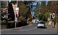
The King's Road, Belfast
The King’s Road, on the western side of its crossroads with the Knock Road.
Image: © Albert Bridge
Taken: 8 Apr 2011
0.11 miles
5
Frosty street sign, Belfast
On the King’s Road, on the western side of the Knock Road.
Image: © Albert Bridge
Taken: 8 Jan 2010
0.11 miles
6
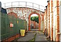
Former Knock tram depot, Belfast
The Belfast Corporation’s Knock tram depot, on the Upper Newtownards Road near the Knock crossroads Image closed in 1947. It passed to the Corporation’s Electricity Department (later Northern Ireland Electricity). Track remained in-situ until the early 1990’s when it was removed to the Ulster Folk and Transport Museum. Much of the depot and yard remained (well after privatisation) until fairly recently when it was sold and replaced by a block of shops. The remains of the roofless shed have survived.
Note added 2 August 2011: the remains of the shed have now been demolished.
Image: © Albert Bridge
Taken: 2 Aug 2009
0.11 miles
7
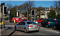
The Knock Road, Belfast (8)
The crossroads, on the Knock Road, with the King’s Road Image (behind the red van). There are various filters here for traffic turning right.
Image: © Albert Bridge
Taken: 8 Apr 2011
0.11 miles
8
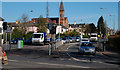
The Knock Road, Belfast (9)
The Knock Road, at the crossroads with the King’s Road Image, looking in the direction of the Upper Newtownards Road.
Image: © Albert Bridge
Taken: 8 Apr 2011
0.11 miles
9
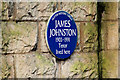
James Johnston plaque, Belfast
A plaque, on the boundary wall of a house on the Knock Road, commemorating the tenor James Johnston http://www.ulsterhistory.co.uk/johnston.htm. Its position makes it accessible to the public without disturbing the privacy of the residents.
Image: © Albert Bridge
Taken: 18 Jan 2010
0.11 miles
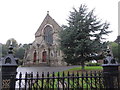
10
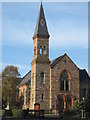
Knock Methodist Church
Built of scrabo sandstone, the church was dedicated on 13 June 1883.
Image: © Brian Shaw
Taken: 21 Nov 2005
0.11 miles