IMAGES TAKEN NEAR TO
Kings Road, BELFAST, BT5 6JG
Introduction
This page details the photographs taken nearby to Kings Road, BT5 6JG by members of the Geograph project.
The Geograph project started in 2005 with the aim of publishing, organising and preserving representative images for every square kilometre of Great Britain, Ireland and the Isle of Man.

There are currently over 7.5m images from over14,400 individuals and you can help contribute to the project by visiting https://www.geograph.org.uk
Image Map
Images are licensed for reuse under creativecommons.org/licenses/by-sa/2.0
Notes
- Clicking on the map will re-center to the selected point.
- The higher the marker number, the further away the image location is from the centre of the postcode.
Image Listing (72 Images Found)
Images are licensed for reuse under creativecommons.org/licenses/by-sa/2.0
Image
Details
Distance
1
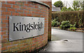
Kingsleigh sign, Belfast
A developer’s street-name sign at the King’s Road Image end of Kingsleigh (shown on the OS 1:12,000 map but not on the Google version) – a suburban cul-de-sac.
Image: © Albert Bridge
Taken: 8 Dec 2011
0.05 miles
2
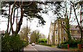
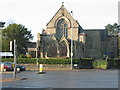
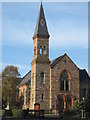
St Columba's church, Knock, Belfast
St Columba’s Church of Ireland on the King’s Road at Knock. Completed in 1896 to a design by Samuel P Close who also designed Fisherwick Presbyterian Image, St Mary Magdalene Image and St Nicholas’s Image Image
Image: © Albert Bridge
Taken: 1 Apr 2011
0.05 miles
3
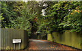
King's Park Lane, Belfast
Discretely hidden suburban thoroughfare, off the King’s Road.
Image: © Albert Bridge
Taken: 5 Sep 2011
0.07 miles
4
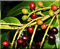
Laurel berries, Belfast (2)
Ripening laurel berries, along the Comber Greenway, near the Knock Road. Just over a fortnight ago the seasonal colour was green Image
Image: © Albert Bridge
Taken: 15 Aug 2011
0.07 miles
5
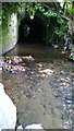
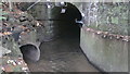
BCDR first culvert over Knock River (upstream end)
The Belfast and County Down Railway track between Belfast and Comber, now the Comber Greenway, required three culverts to maintain the flow of the Knock River. This is the upstream end of the first culvert.
Image: © Alan Collins
Taken: 5 Nov 2013
0.07 miles
6
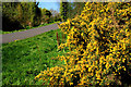
Whin bushes, Belfast
Whin bushes, in full flower, along the Comer Greenway, close to the Sandown Road.
Image: © Albert Bridge
Taken: 8 Apr 2011
0.07 miles
7
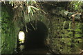
BCDR first culvert over Knock River (downstream end)
The Belfast and County Down Railway track between Belfast and Comber, now the Comber Greenway, required three culverts to maintain the flow of the Knock River. This is the downstream end of the first culvert.
Image: © Alan Collins
Taken: 21 Nov 2013
0.09 miles
9
Knock Methodist Church
Built of scrabo sandstone, the church was dedicated on 13 June 1883.
Image: © Brian Shaw
Taken: 21 Nov 2005
0.10 miles
10
BCDR second culvert over Knock River (downstream end)
The Belfast and County Down Railway track between Belfast and Comber, now the Comber Greenway, required three culverts to maintain the flow of the Knock River. This is the downstream end of the second culvert.
Image: © Alan Collins
Taken: 5 Nov 2013
0.14 miles