IMAGES TAKEN NEAR TO
Green Road, BELFAST, BT5 6JB
Introduction
This page details the photographs taken nearby to Green Road, BT5 6JB by members of the Geograph project.
The Geograph project started in 2005 with the aim of publishing, organising and preserving representative images for every square kilometre of Great Britain, Ireland and the Isle of Man.

There are currently over 7.5m images from over14,400 individuals and you can help contribute to the project by visiting https://www.geograph.org.uk
Image Map
Images are licensed for reuse under creativecommons.org/licenses/by-sa/2.0
Notes
- Clicking on the map will re-center to the selected point.
- The higher the marker number, the further away the image location is from the centre of the postcode.
Image Listing (146 Images Found)
Images are licensed for reuse under creativecommons.org/licenses/by-sa/2.0
Image
Details
Distance
1
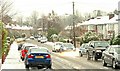
Snow, Belfast 2009 (3)
Image: © Albert Bridge
Taken: 5 Feb 2009
0.04 miles
2
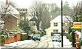
Snow, Belfast 2009 (1)
The snow which hit London and the South East earlier this week finally reached Belfast early today. At 09.18, when the work and school traffic has normally passed there is a quiet period before the off-peak traffic builds up. Not today as suburban drivers waited for a (limited) opportunity to emerge from Knockhill Park (“Knock Hill” on the Google map) onto the Upper Newtownards Road. Continue to Image
Image: © Albert Bridge
Taken: 5 Feb 2009
0.08 miles
3
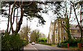
St Columba's church, Knock, Belfast
St Columba’s Church of Ireland on the King’s Road at Knock. Completed in 1896 to a design by Samuel P Close who also designed Fisherwick Presbyterian Image, St Mary Magdalene Image and St Nicholas’s Image Image
Image: © Albert Bridge
Taken: 1 Apr 2011
0.10 miles
4
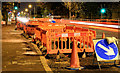
The Upper Newtownards Road (EWAY), Knock, Belfast (November 2014)
Excavations, for the relocation of electricity cables, on the inward lanes of the Upper Newtownards Road, just east of Winston Gardens (at the pelican lights). My understanding is that there will be a new bus lane here to facilitate the EWAY.
Image: © Albert Bridge
Taken: 3 Nov 2014
0.10 miles
5
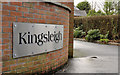
Kingsleigh sign, Belfast
A developer’s street-name sign at the King’s Road Image end of Kingsleigh (shown on the OS 1:12,000 map but not on the Google version) – a suburban cul-de-sac.
Image: © Albert Bridge
Taken: 8 Dec 2011
0.10 miles
6
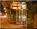
Bus stop (EWAY), Upper Newtownards Road, Knock, Belfast (November 2014)
The inward Metro/Ulsterbus stop and shelter at Winston Gardens. There is no existing bus lane but my understanding is that there will be a new one provided to facilitate the EWAY. I don’t know whether this stop will be served by the EWAY buses.
Image: © Albert Bridge
Taken: 3 Nov 2014
0.10 miles
7
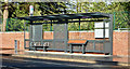
Greenwood Park EWAY halt, Belfast - February 2018(1)
The outward EWAY halt, close to Greenwood Park Image, on the Upper Newtownards Road.
Image: © Albert Bridge
Taken: 6 Feb 2018
0.10 miles
8
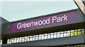
Greenwood Park EWAY halt, Belfast - February 2018(2)
The name sign.
Image: © Albert Bridge
Taken: 6 Feb 2018
0.10 miles
9
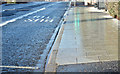
Greenwood Park EWAY halt, Belfast - February 2018(3)
The halts are provided with new paving and raised kerbs to match the level of the Glider buses.
Image: © Albert Bridge
Taken: 6 Feb 2018
0.10 miles
10
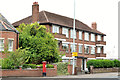
Knockhill Court, Belfast
A small block of apartments, on the Upper Newtownards Road at the corner of Knockhill Park, built (I think) in the early 1960’s.
Image: © Albert Bridge
Taken: 29 Aug 2013
0.11 miles