IMAGES TAKEN NEAR TO
Sandhill Park, BELFAST, BT5 6DS
Introduction
This page details the photographs taken nearby to Sandhill Park, BT5 6DS by members of the Geograph project.
The Geograph project started in 2005 with the aim of publishing, organising and preserving representative images for every square kilometre of Great Britain, Ireland and the Isle of Man.

There are currently over 7.5m images from over14,400 individuals and you can help contribute to the project by visiting https://www.geograph.org.uk
Image Map
Images are licensed for reuse under creativecommons.org/licenses/by-sa/2.0
Notes
- Clicking on the map will re-center to the selected point.
- The higher the marker number, the further away the image location is from the centre of the postcode.
Image Listing (53 Images Found)
Images are licensed for reuse under creativecommons.org/licenses/by-sa/2.0
Image
Details
Distance
1
The Knock River, Orangefield Park, Belfast - July 2014(2)
The improved channel of the Knock River and the new flood embankment (left), looking upstream towards Clarawood.
Image: © Albert Bridge
Taken: 12 Jul 2014
0.05 miles
2
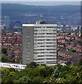
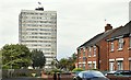
Clarawood House, Belfast
15-storey tower block located at the end of Clara Way in Belfast. The tower, completed in 1967 by local firm F.B. McKee, is 44 metres tall and contains 57 flats. It is part of the Clarawood estate, built in the late 1940s by the Belfast Corporation, although this is the only tower block in the development. The view is from Knock Burial Ground (Knockmount Park).
Image: © Rossographer
Taken: 11 Sep 2011
0.06 miles
3
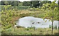
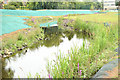
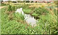
Pond, Orangefield Park, Belfast (September 2015)
A new pond, created as part of the Connswater Greenway scheme, close to the back of Clarawood House Image
Image: © Albert Bridge
Taken: 10 Sep 2015
0.06 miles
4
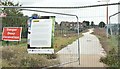
New path, Clarawood, Belfast (September 2015)
A new paved path (not yet open), created as part of the Connswater Greenway scheme, running south, close to the back of Clarawood House Image
Image: © Albert Bridge
Taken: 10 Sep 2015
0.06 miles
5
Clarawood House, Belfast (September 2015)
See Image The eastern side of Clarawood House seen from Sandhill Parade.
Image: © Albert Bridge
Taken: 10 Sep 2015
0.08 miles
6
The Knock River, Orangefield Park, Belfast (September 2015)
The Knock River, after completion of the flood alleviation works, with vegetation now growing along the banks, looking downstream towards here Image (October 2013).
Image: © Albert Bridge
Taken: 10 Sep 2015
0.10 miles
7
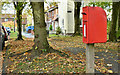
Postbox BT5 791D, Belfast (October 2018)
Post-mounted EIIR postbox (BT5 791D) at Clarawood Park/Clarawood Crescent.
Image: © Albert Bridge
Taken: 31 Oct 2018
0.13 miles
8
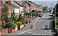
The Orangefield Road, Belfast (2)
See Image Much further east along the road, looking towards the Sandown Road from the corner of Orangefield Grove, where more traffic calming measures are used. The Orangefield Road and its continuation, Sandhill Gardens, run almost in a straight line, for more than half a mile.
Image: © Albert Bridge
Taken: 21 Apr 2011
0.13 miles
9
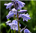
Bluebells, Belfast
Bluebells were quite common today along the Greenway, both in the open and under the trees. This is part of a clump between the North Road and the Sandown Road.
Image: © Albert Bridge
Taken: 28 Apr 2012
0.13 miles
10
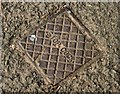
Stop cock cover, Orangefield Park, Belfast (September 2015)
An anonymous stop cock cover in the path near the tennis courts. It pre-dates the Connswater Greenway works. For others see http://www.geograph.org.uk/of/stop+cock+cover
Image: © Albert Bridge
Taken: 10 Sep 2015
0.14 miles