IMAGES TAKEN NEAR TO
Orangefield Avenue, BELFAST, BT5 6DH
Introduction
This page details the photographs taken nearby to Orangefield Avenue, BT5 6DH by members of the Geograph project.
The Geograph project started in 2005 with the aim of publishing, organising and preserving representative images for every square kilometre of Great Britain, Ireland and the Isle of Man.

There are currently over 7.5m images from over14,400 individuals and you can help contribute to the project by visiting https://www.geograph.org.uk
Image Map
Images are licensed for reuse under creativecommons.org/licenses/by-sa/2.0
Notes
- Clicking on the map will re-center to the selected point.
- The higher the marker number, the further away the image location is from the centre of the postcode.
Image Listing (94 Images Found)
Images are licensed for reuse under creativecommons.org/licenses/by-sa/2.0
Image
Details
Distance
1
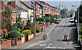
Cyprus Avenue
The inspiration for the Van Morrison song of the same name.
Image: © Paul McIlroy
Taken: 22 Oct 2005
0.05 miles
2
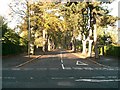
The Orangefield Road, Belfast (2)
See Image Much further east along the road, looking towards the Sandown Road from the corner of Orangefield Grove, where more traffic calming measures are used. The Orangefield Road and its continuation, Sandhill Gardens, run almost in a straight line, for more than half a mile.
Image: © Albert Bridge
Taken: 21 Apr 2011
0.07 miles
3
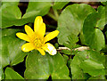
Celandine, Belfast
Celandine, one of the signs of spring, growing beside the Comber Greenway, near the North Road bridge.
Image: © Albert Bridge
Taken: 8 Apr 2013
0.09 miles
4
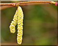
Catkins, Belfast
Some of the many hazel catkins, now in flower, along the Comber Greenway.
Image: © Albert Bridge
Taken: 14 Jan 2014
0.09 miles
5
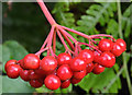
Cotoneaster berries, Belfast (3)
Cotoneaster berries growing along the Comber Greenway, between the Sandown and North Roads.
Image: © Albert Bridge
Taken: 9 Sep 2013
0.10 miles
6
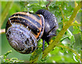
Snail, Belfast (3)
A snail, feeding on leaves, along the Comber Greenway, between the Sandown and North Roads.
Image: © Albert Bridge
Taken: 9 Sep 2013
0.10 miles
7
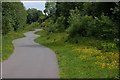
Old railway, Belfast
See Image This is a view of the old line/footpath looking towards Comber. It was managed by the Conservation Volunteers as a semi-wild area but was substantially altered, a few years ago, when a new water main was laid under this section. Many would like to see it re-opened as a tramway but official thinking is directed towards a guided busway Image
Image: © Albert Bridge
Taken: 30 May 2007
0.11 miles
8
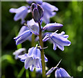
Bluebells, Belfast
Bluebells were quite common today along the Greenway, both in the open and under the trees. This is part of a clump between the North Road and the Sandown Road.
Image: © Albert Bridge
Taken: 28 Apr 2012
0.11 miles
9
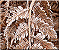
Frosty bracken, Belfast
There was quite a heavy frost overnight. This bracken is beside the Comber Greenway.
Image: © Albert Bridge
Taken: 14 Jan 2014
0.12 miles
10
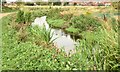
The Knock River, Orangefield Park, Belfast (September 2015)
The Knock River, after completion of the flood alleviation works, with vegetation now growing along the banks, looking downstream towards here Image (October 2013).
Image: © Albert Bridge
Taken: 10 Sep 2015
0.12 miles