IMAGES TAKEN NEAR TO
Roselick Road, PORTRUSH, BT56 8PE
Introduction
This page details the photographs taken nearby to Roselick Road, BT56 8PE by members of the Geograph project.
The Geograph project started in 2005 with the aim of publishing, organising and preserving representative images for every square kilometre of Great Britain, Ireland and the Isle of Man.

There are currently over 7.5m images from over14,400 individuals and you can help contribute to the project by visiting https://www.geograph.org.uk
Image Map
Images are licensed for reuse under creativecommons.org/licenses/by-sa/2.0
Notes
- Clicking on the map will re-center to the selected point.
- The higher the marker number, the further away the image location is from the centre of the postcode.
Image Listing (6 Images Found)
Images are licensed for reuse under creativecommons.org/licenses/by-sa/2.0
Image
Details
Distance
1
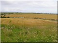
Craigtown More
It is to the south of Portrush
Image: © Kenneth Allen
Taken: 15 Aug 2007
0.04 miles
2
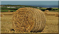
Straw bales near Portrush (1)
Straw bales in a field beside the Roselick Road, close to the corner of the Loguestown Road. The Atlantic is in the background.
Image: © Albert Bridge
Taken: 4 Sep 2012
0.10 miles
3
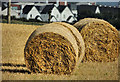
Straw bales near Portrush (2)
See Image Bales in the same field, at the corner of the Roselick Road and the Loguestown Road. This view shows how Portrush has spread on its southern side.
Image: © Albert Bridge
Taken: 4 Sep 2012
0.14 miles
4
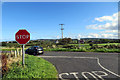
Near Portrush
Junction of Roselick Road and Loguestown Road.
Image: © Robert Ashby
Taken: 7 Oct 2015
0.14 miles
5
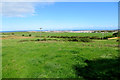
View from Roselick Road
Looking north on a sunny October day towards Portrush in the townland of Carnalridge.
Image: © Robert Ashby
Taken: 7 Oct 2015
0.24 miles
6
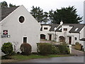
Holiday cottages
The self catering cottages at Maddybenny Farm.The owners also run a wellknown B&B as well riding stables.
Image: © Willie Duffin
Taken: 12 Feb 2009
0.24 miles