IMAGES TAKEN NEAR TO
Ballymacrea Road, PORTRUSH, BT56 8NR
Introduction
This page details the photographs taken nearby to Ballymacrea Road, BT56 8NR by members of the Geograph project.
The Geograph project started in 2005 with the aim of publishing, organising and preserving representative images for every square kilometre of Great Britain, Ireland and the Isle of Man.

There are currently over 7.5m images from over14,400 individuals and you can help contribute to the project by visiting https://www.geograph.org.uk
Image Map
Images are licensed for reuse under creativecommons.org/licenses/by-sa/2.0
Notes
- Clicking on the map will re-center to the selected point.
- The higher the marker number, the further away the image location is from the centre of the postcode.
Image Listing (3 Images Found)
Images are licensed for reuse under creativecommons.org/licenses/by-sa/2.0
Image
Details
Distance
1
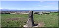
Standing stone at Ballycraig Upper
Looking north-west towards Portrush on the coast.
Image: © Kenneth Allen
Taken: 17 Aug 2006
0.08 miles
2
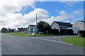
Ballywillan Orange Hall
Located at the junction of Ballywillen Road and Magheraboy Road.
Image: © Robert Ashby
Taken: 18 Sep 2015
0.18 miles
3
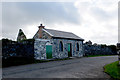
Ballywillin Old Church 3
The front of the presumed caretakers/watchmans cottage with nicely glazed Gothic arched windows. Probably not regularly lived in but not sure what its function might be. It faces out over the more modern cemetery.
Image: © Robert Ashby
Taken: 7 Oct 2015
0.25 miles