IMAGES TAKEN NEAR TO
Strand Avenue, PORTRUSH, BT56 8ND
Introduction
This page details the photographs taken nearby to Strand Avenue, BT56 8ND by members of the Geograph project.
The Geograph project started in 2005 with the aim of publishing, organising and preserving representative images for every square kilometre of Great Britain, Ireland and the Isle of Man.

There are currently over 7.5m images from over14,400 individuals and you can help contribute to the project by visiting https://www.geograph.org.uk
Image Map
Images are licensed for reuse under creativecommons.org/licenses/by-sa/2.0
Notes
- Clicking on the map will re-center to the selected point.
- The higher the marker number, the further away the image location is from the centre of the postcode.
Image Listing (24 Images Found)
Images are licensed for reuse under creativecommons.org/licenses/by-sa/2.0
Image
Details
Distance
1
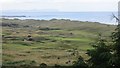
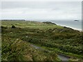
Dunes, Portrush
Will Royal Portrush make the Open roster one day?
--
Yes. It was announced just after I posted this that Royal Portrush is back on the roster and may hold The Open in 2019.
Image: © Richard Webb
Taken: 4 Aug 2013
0.07 miles
2
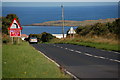
The Ballybogey Road near the Whiterocks
The Ballybogey Road runs from the Ballymoney roundabout, through level countryside, to the Whiterocks, near Portrush. This is the road as it begins its descent towards the Whiterocks. The Skerries and the north Atlantic can be seen in the background.
Image: © Albert Bridge
Taken: 17 Aug 2006
0.08 miles
3
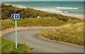
The road to the White Rocks near Portrush
The shore, at the White Rocks is reached by a winding, steep and narrow road Image Coleraine Council has provided a number of discreetly hidden car parks along the road. The view is towards the shore.
Image: © Albert Bridge
Taken: 2 May 2008
0.14 miles
4
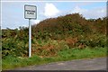
Road sign near Portrush
There are many roads in NI suitable for only one vehicle at a time. Signposted passing places such as this one, on the road to the Whiterocks near Portrush, are unusual.
Image: © Albert Bridge
Taken: 28 Sep 2007
0.15 miles
5
Royal Portrush Golf Club
The Dunluce Links is rated as one of the most challenging and spectacular links courses in the world. The Links is named after the nearby ruins of the medieval Dunluce Castle located on the edge of a basalt outcropping overlooking the sea between Portrush and Portballintrae.
Image: © Russel Wills
Taken: 17 Sep 2023
0.15 miles
6
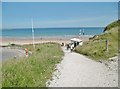
Dunluce, coastal path
From the car parks to White Rocks Beach; lifeguard hut ahead.
Image: © Mike Faherty
Taken: 27 Jun 2018
0.15 miles
7
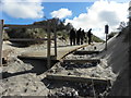
Crumbling pathway, Whiterocks beach, Portrush
Image: © Kenneth Allen
Taken: 27 Apr 2016
0.16 miles
9
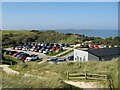
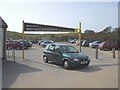
East Strand car park
A large and multi-levelled car park at East Strand, White Rocks Bay. Well appointed facilities are provided at the lowest, shore level. In the distance can be seen The Skerries, tabular islands formed by offshore outcrop of the Portrush Sill, an igneous intrusion into Jurassic strata associated with the Palaeogene magmatism of the Antrim Plateau Lavas.
Image: © Jonathan Wilkins
Taken: 6 Sep 2024
0.17 miles
10
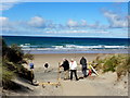
Tourists, Portrush
Pictured at the end of the path leading to the Whiterocks beach
Image: © Kenneth Allen
Taken: 27 Apr 2016
0.20 miles