IMAGES TAKEN NEAR TO
Ballyreagh Road, PORTRUSH, BT56 8LP
Introduction
This page details the photographs taken nearby to Ballyreagh Road, BT56 8LP by members of the Geograph project.
The Geograph project started in 2005 with the aim of publishing, organising and preserving representative images for every square kilometre of Great Britain, Ireland and the Isle of Man.

There are currently over 7.5m images from over14,400 individuals and you can help contribute to the project by visiting https://www.geograph.org.uk
Image Map
Images are licensed for reuse under creativecommons.org/licenses/by-sa/2.0
Notes
- Clicking on the map will re-center to the selected point.
- The higher the marker number, the further away the image location is from the centre of the postcode.
Image Listing (25 Images Found)
Images are licensed for reuse under creativecommons.org/licenses/by-sa/2.0
Image
Details
Distance
1
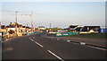
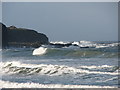
Over Black Hill
Over the hill and on to the coast road at Ballyreagh. Image
Image: © Willie Duffin
Taken: 16 May 2008
0.02 miles
2
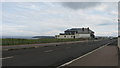
Unoccupied Restaurant
This is the former "Some Plaice Else" restaurant on the Ballyreagh road. It is on a magnificent site overlooking Portrush and Ramore Head to the East and Donegal to the Northwest but has unfortunately been unable to attract enough trade to remain viable.
Image: © Willie Duffin
Taken: 29 Apr 2008
0.06 miles
3
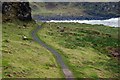
The Port Path near Portrush (2)
See Image The path (looking towards Portstewart) to the east of the previous photo with the Atlantic on the right.
Image: © Albert Bridge
Taken: 15 Dec 2007
0.07 miles
4
Dhu Varren at sunset
Looking towards Dhu Varren or Black Rock as its known locally just as the sun is setting. The rocks and cliff face look particularly black in this light.
Image: © Willie Duffin
Taken: 14 Oct 2018
0.08 miles
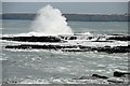
5
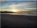
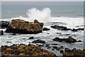
Breaking waves Portrush
Waves breaking over the rocks at Blackrock.
Image: © Willie Duffin
Taken: 2 Feb 2014
0.09 miles
6
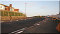
Black Hill
Up and over Black Hill, a sweeping left hand bend. Image
Image: © Willie Duffin
Taken: 16 May 2008
0.11 miles
7
Atlantic waves near Portrush (1)
See Image An Atlantic wave rolling in as seen from the Port Path slightly to the east of the previous photo.
Image: © Albert Bridge
Taken: 15 Dec 2007
0.11 miles
8
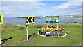
Major Golf Capital of the World
Sign on the edge of Portrush at a time when Northern Ireland was producing Major winners in some profusion.
Names on the sign:Fred Daly (Open 1947), Graeme McDowell (US Open 2010), Darren Clarke (The Open 2011).
Image: © Richard Webb
Taken: 4 Aug 2013
0.11 miles
9
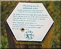
Grave near Portrush (2)
See Image This explanatory sign is close to the grave.
Image: © Albert Bridge
Taken: 15 Dec 2007
0.12 miles
10
Atlantic waves near Portrush (2)
See Image The shore from the same place as the previous photo but looking towards Portrush. The Port Path is well sheltered here but the rocks are exposed to the Atlantic.
Image: © Albert Bridge
Taken: 15 Dec 2007
0.12 miles