IMAGES TAKEN NEAR TO
Old Castle Court, Ballyreagh Road, PORTRUSH, BT56 8GR
Introduction
This page details the photographs taken nearby to Old Castle Court, Ballyreagh Road, BT56 8GR by members of the Geograph project.
The Geograph project started in 2005 with the aim of publishing, organising and preserving representative images for every square kilometre of Great Britain, Ireland and the Isle of Man.

There are currently over 7.5m images from over14,400 individuals and you can help contribute to the project by visiting https://www.geograph.org.uk
Image Map
Images are licensed for reuse under creativecommons.org/licenses/by-sa/2.0
Notes
- Clicking on the map will re-center to the selected point.
- The higher the marker number, the further away the image location is from the centre of the postcode.
Image Listing (19 Images Found)
Images are licensed for reuse under creativecommons.org/licenses/by-sa/2.0
Image
Details
Distance
1
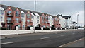
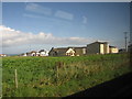
Apartment block
A large group of apartment blocks on the site of the former Causeway Coast Hotel on the Ballyreagh road.
Image: © Willie Duffin
Taken: 29 Apr 2008
0.01 miles
2
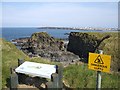
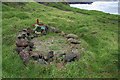
Site of Ballyreagh Castle
The scant remains of Dunferte castle, now only known by the name of the Castle of Ballyreagh, the townland in which it is situated, consists of one small mortar & basalt boulder wall - part of the E-W wall which once cut off the landward approach, i.e. the S wall of the castle. The mortar has flint & pebble inclusions. The W edge of the promontory shows a slight lip 0.6m high, which could reflect a buried wall, but this is doubtful. The wall remnant is at most 0.9m high & from the wall to the edge of the promontory is 20m. It is near the house occupied by the late General Beresford, at Dhu Varren.
Image: © Kenneth Allen
Taken: 2 Apr 2007
0.05 miles
3
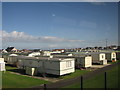
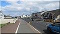
Carrick-Dhu Caravan Park (rear view)
The rear view of the caravan park at Ballyreagh taken from the train.
Image: © Willie Duffin
Taken: 9 Sep 2010
0.06 miles
4
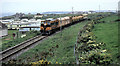
Weed-spraying train near Portrush
See Image The previous day (in much less pleasant weather) the train had sprayed the Londonderry and Portrush lines. It is seen returning from Portrush past Juniper Hill caravan site.
Image: © Albert Bridge
Taken: 5 Jun 1985
0.07 miles
5
Inn on the Coast, Ballyreagh
Rear view of the Inn on the Coast Hotel/public house as seen from the train going towards Coleraine
Image: © Willie Duffin
Taken: 9 Sep 2010
0.11 miles
6
Ballyreagh Road
Recent expansion of Portrush.
Image: © Richard Webb
Taken: 4 Aug 2013
0.12 miles
7
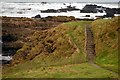
The Port Path near Portrush (1)
The Port Path runs from Portstewart to Portrush. Much of it follows the Atlantic coast. This is the entrance to the path at Ballyreagh. Portrush is to the right.
Image: © Albert Bridge
Taken: 15 Dec 2007
0.12 miles
8
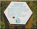
Grave near Portrush (2)
See Image This explanatory sign is close to the grave.
Image: © Albert Bridge
Taken: 15 Dec 2007
0.13 miles
9
Grave near Portrush (1)
This is supposed to be the grave of an unknown sailor. It is close to the Port Path to the east of Image See also Image
Image: © Albert Bridge
Taken: 15 Dec 2007
0.13 miles
10
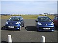
Cars parked at Ballyreagh Golf Course
His 'n' hers? In the background is Portrush.
Image: © Kenneth Allen
Taken: 2 Apr 2007
0.15 miles