IMAGES TAKEN NEAR TO
Princess Street, PORTRUSH, BT56 8AX
Introduction
This page details the photographs taken nearby to Princess Street, BT56 8AX by members of the Geograph project.
The Geograph project started in 2005 with the aim of publishing, organising and preserving representative images for every square kilometre of Great Britain, Ireland and the Isle of Man.

There are currently over 7.5m images from over14,400 individuals and you can help contribute to the project by visiting https://www.geograph.org.uk
Image Map
Images are licensed for reuse under creativecommons.org/licenses/by-sa/2.0
Notes
- Clicking on the map will re-center to the selected point.
- The higher the marker number, the further away the image location is from the centre of the postcode.
Image Listing (538 Images Found)
Images are licensed for reuse under creativecommons.org/licenses/by-sa/2.0
Image
Details
Distance
1
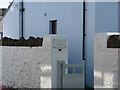
Gateway to Coastguard Cottages
The gate leading into a row of cottages formerly used by H.M. Coastguard.
Image: © Willie Duffin
Taken: 4 Oct 2010
0.02 miles
2
Causeway View Lane
The junction of Ramore St. and Causeway View lane.
Image: © Willie Duffin
Taken: 4 Oct 2010
0.02 miles
3
Coastguard Cottages, Portrush
Looking along the row of cottages. A badly composed shot as the sun was reflecting into the camera lens from both directions.
Image: © Willie Duffin
Taken: 4 Oct 2010
0.03 miles
4
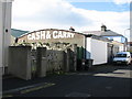
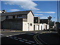
Cash and Carry warehouse
Small cash and carry warehouse in Causeway View Lane.
Image: © Willie Duffin
Taken: 4 Oct 2010
0.03 miles
5
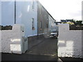
Causeway View Mews, Portrush
Entrance to a mews development off Causeway View Lane.
Image: © Willie Duffin
Taken: 4 Oct 2010
0.04 miles
6
Mayflower, Portrush
It is located along Main Street
Image: © Kenneth Allen
Taken: 3 Jun 2011
0.05 miles
7
Spar, Portrush
It is located along Main Street
Image: © Kenneth Allen
Taken: 3 Jun 2011
0.05 miles
8
Equilibrium, Portrush
It is located at Main Street
Image: © Kenneth Allen
Taken: 3 Jun 2011
0.05 miles
9
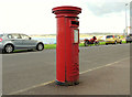
Pillar box, Portrush
EIIR pillar box (BT56 1) at Lansdowne Crescent.
Image: © Albert Bridge
Taken: 14 Aug 2012
0.05 miles
10

Portrush Sill
These rocks were the site of one of the great controversies in the history of geology. There were two opposing schools of thought: the Neptunists believed that all rocks were formed by sediments accumulating on the sea bed, and the Vulcanists, who believed that some rocks, in particular basalts, were formed by volcanic activity.
Here in these rocks at Portrush were found ammonites, apparently in basalt, so the Neptunists cited these rocks as evidence supporting their hypothesis.
Later study showed, however, that the ammonites were in fact in the underlying layer of mudstones, which had been baked so hard by the heat of the basalt on top of them that they had taken on a similar appearance and hardness as the basalt.
The Neptunists' hypothesis has since been clearly demonstrated to be false.
In this view, the flat sloping surface is the baked mudstone, and the isolated blocks are the igneous rocks, now classified as dolerite rather than basalt.
Image: © Anne Burgess
Taken: 1 Jun 2007
0.05 miles