IMAGES TAKEN NEAR TO
Orby Grange, BELFAST, BT5 5PR
Introduction
This page details the photographs taken nearby to Orby Grange, BT5 5PR by members of the Geograph project.
The Geograph project started in 2005 with the aim of publishing, organising and preserving representative images for every square kilometre of Great Britain, Ireland and the Isle of Man.

There are currently over 7.5m images from over14,400 individuals and you can help contribute to the project by visiting https://www.geograph.org.uk
Image Map
Images are licensed for reuse under creativecommons.org/licenses/by-sa/2.0
Notes
- Clicking on the map will re-center to the selected point.
- The higher the marker number, the further away the image location is from the centre of the postcode.
Image Listing (90 Images Found)
Images are licensed for reuse under creativecommons.org/licenses/by-sa/2.0
Image
Details
Distance
1

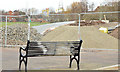
New changing rooms, Dixon Park, Belfast (August 2015)
New changing rooms, at the Dixon Park playing fields, Grand Parade – built as part of the Connswater Greenway scheme (section C5).
Image: © Albert Bridge
Taken: 2 Aug 2015
0.10 miles
2
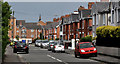
Orby Drive, Belfast
A very long street, running parallel to and to the north east of the Castlereagh Road. This part, mainly semis, is between Grand Parade and Orby Park (background). See also Image
Image: © Albert Bridge
Taken: 24 May 2011
0.12 miles
3
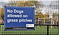
"No dogs" sign, Dixon Park, Belfast (November 2016)
A new “No dogs allowed” sign at the Dixon Park playing fields. For something similar see Image
Image: © Albert Bridge
Taken: 14 Nov 2016
0.14 miles
4
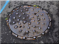
Brown's manhole cover, Belfast (3)
See http://www.geograph.org.uk/search.php?i=23150327. Another cover from Brown & Co. This one, on the Castlereagh Road, opposite Loopland Park, omits the foundry’s address.
Image: © Albert Bridge
Taken: 15 Jul 2011
0.15 miles
5
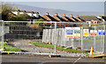
Elmgrove path improvements, Belfast (January 2015)
Improvement work underway, on a path, on the south western side of the Dixon Park playing fields, close to Grand Parade. Officially described as a “New / improved combined cycleway and walkway” in the area leading towards here Image
Image: © Albert Bridge
Taken: 10 Jan 2015
0.15 miles
6
The Loop Bridge, Belfast
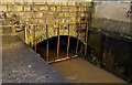
The Loop River flowing under the Loop Bridge on the Castlereagh Road. The Loop joins the Knock River Image a short distance downstream. Several streets nearby have “Loopland” in their names. Note: this photograph appears as a matter of neutral geographical record only and should not be interpreted as being part of any campaign associated with flooding in east Belfast.
Image: © Albert Bridge
Taken: 19 Dec 2011
0.15 miles
7
New path, Dixon Park, Belfast - February 2015(2)
See Image The works seen from inside Dixon Park.
Image: © Albert Bridge
Taken: 21 Feb 2015
0.15 miles
8

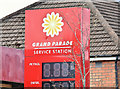
New petrol station, Grand Parade, Belfast - December 2016(2)
Not hyperinflation or even the first of April – just a petrol price sign under test.
Image: © Albert Bridge
Taken: 24 Dec 2016
0.16 miles
9
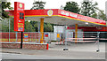
Petrol station, Grand Parade, Belfast
An independent station which seems to be closed pending the installation of new tanks. Image shows the replacement.
Image: © Albert Bridge
Taken: 5 Oct 2013
0.16 miles
10
Former Grand Parade petrol station, Belfast (April 2016)
Long closed but the old forecourt sign remains. The station was independent.
Image: © Albert Bridge
Taken: 25 Apr 2016
0.16 miles