IMAGES TAKEN NEAR TO
Cyprus Avenue, BELFAST, BT5 5NT
Introduction
This page details the photographs taken nearby to Cyprus Avenue, BT5 5NT by members of the Geograph project.
The Geograph project started in 2005 with the aim of publishing, organising and preserving representative images for every square kilometre of Great Britain, Ireland and the Isle of Man.

There are currently over 7.5m images from over14,400 individuals and you can help contribute to the project by visiting https://www.geograph.org.uk
Image Map
Images are licensed for reuse under creativecommons.org/licenses/by-sa/2.0
Notes
- Clicking on the map will re-center to the selected point.
- The higher the marker number, the further away the image location is from the centre of the postcode.
Image Listing (224 Images Found)
Images are licensed for reuse under creativecommons.org/licenses/by-sa/2.0
Image
Details
Distance
1
Snow, Belfast 2009 (8)
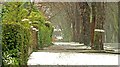
See Image At 14.42 the road in Cyprus Avenue was clear but some slushy snow remained to encourage a pedestrian to exercise care on the footpath.
Image: © Albert Bridge
Taken: 5 Feb 2009
0.01 miles
2
Beech nuts, Belfast (August 2017)
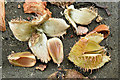
A few of the many crunchy beech nuts and shells found along Cyprus Avenue.
Image: © Albert Bridge
Taken: 28 Aug 2017
0.03 miles
3
Kirkliston Drive sign, Belfast
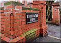
Traditional tiled sign at the Cyprus Avenue end of Kirkliston Drive.
Image: © Albert Bridge
Taken: 18 Feb 2011
0.03 miles
4
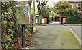
Drop box, Belfast
Image: © Albert Bridge
Taken: 28 Jan 2012
0.03 miles
5
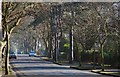
Cyprus Avenue, Belfast
Cyprus Avenue, looking towards the North Road Image from the Beersbridge Road end. The road is wider than might be expected and the trees taller. Image (October 2012) shows the view from the North Road end.
Image: © Albert Bridge
Taken: 11 Feb 2008
0.04 miles
6
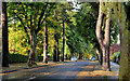
Cyprus Avenue, Belfast (2)
See Image (February 2008). Just over half-way through October and there are some signs of autumn in the trees of Cyprus Avenue. This view is from the North Road end. Image shows the autumn colours in November 2013.
Image: © Albert Bridge
Taken: 17 Oct 2012
0.04 miles
7
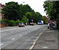
Upper Newtownards Road, Belfast
Looking east along the Upper Newtownards Road.
Image: © Rossographer
Taken: 10 Jul 2008
0.05 miles
8
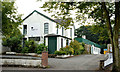
Former "Girton Lodge", Belfast
Built as a house, later a school and then the “Girton Lodge Hotel” at 149 Upper Newtownards Road, it became the “Earlswood Hotel” before closing and lying vacant. Eventually converted and now occupied by a specialist printer http://www.blacksheepdisplay.com/.
Image: © Albert Bridge
Taken: 8 Sep 2013
0.06 miles
9
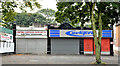
Nos 145-147 Upper Newtownards Road, Belfast
Two single-storey shops on the southern side of the Upper Newtownards Road.
Image: © Albert Bridge
Taken: 8 Sep 2013
0.06 miles
10
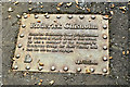
Roderick Chisholm (Titanic plaque), Belfast (August 2017)
Another of the ground plaques commemorating Harland & Wolff employees who died in the sinking of the “Titanic”. Roderick Chisholm, of Sandford Avenue, appears in the 1910 street directory as “Alexandria Villas 6. Chisholm, R., draughtsman”.
Image: © Albert Bridge
Taken: 28 Aug 2017
0.06 miles