IMAGES TAKEN NEAR TO
Mill Pond Court, BELFAST, BT5 5NN
Introduction
This page details the photographs taken nearby to Mill Pond Court, BT5 5NN by members of the Geograph project.
The Geograph project started in 2005 with the aim of publishing, organising and preserving representative images for every square kilometre of Great Britain, Ireland and the Isle of Man.

There are currently over 7.5m images from over14,400 individuals and you can help contribute to the project by visiting https://www.geograph.org.uk
Image Map
Images are licensed for reuse under creativecommons.org/licenses/by-sa/2.0
Notes
- Clicking on the map will re-center to the selected point.
- The higher the marker number, the further away the image location is from the centre of the postcode.
Image Listing (178 Images Found)
Images are licensed for reuse under creativecommons.org/licenses/by-sa/2.0
Image
Details
Distance
1
Abandoned shopping trolley, Belfast
An abandoned shopping trolley, beside the Connswater, between this footbridge Image and the Beersbridge Road.
Image: © Albert Bridge
Taken: 14 Aug 2013
0.02 miles
2
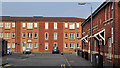
Elmgrove Manor, Belfast
Housing Association accommodation off the Beersbridge Road. Not named on the Google map.
Image: © Albert Bridge
Taken: 16 Nov 2011
0.04 miles
3
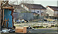
Proposed social housing, Beersbridge Road, Belfast - March 2018(4)
The vacant site behind the existing buildings.
Image: © Albert Bridge
Taken: 12 Mar 2018
0.05 miles
4
Connswater path works, Belfast - April 2016(4)
Construction continuing on the new path between Flora Street (left) and the Connswater. This view is from the Beersbridge Road.
Image: © Albert Bridge
Taken: 27 Apr 2016
0.05 miles
5
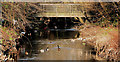
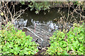
Knock River footbridge, Belfast
At the rear of Bloomfield Parade. Tatty perhaps but the water is clean enough to support a flock of mallard.
Image: © Albert Bridge
Taken: 25 Jan 2010
0.06 miles
6
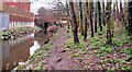
The Connswater, Belfast (7)
Part of the Connswater, at the Flora Street walkway, as it flows under the Beersbridge Road Image (background).
Image: © Albert Bridge
Taken: 18 Feb 2011
0.06 miles
7
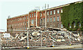
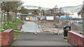
Proposed social housing, Beersbridge Road, Belfast - June 2019(1)
The vacant buildings have now been demolished leaving a temporary view through to the Owen O’Cork mill Image
Image: © Albert Bridge
Taken: 1 Jun 2019
0.07 miles
8
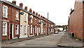
Flora Street, Belfast
A late 19th century street running from Mayflower Street Image to the Beersbridge Road (background).
Image: © Albert Bridge
Taken: 22 Aug 2011
0.07 miles
9
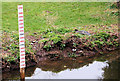
The Knock River, Belfast (11)
A depth marker in this section of the Knock River Image
Image: © Albert Bridge
Taken: 18 Feb 2011
0.07 miles
10
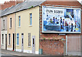
Nos 299&301 Beersbridge Road, Belfast (2013-1)
Two derelict houses (right) which have been disguised to look like one occupied and one blocked up. Image is a close view of the disguise.
Image: © Albert Bridge
Taken: 14 Aug 2013
0.07 miles