IMAGES TAKEN NEAR TO
North Road, BELFAST, BT5 5NF
Introduction
This page details the photographs taken nearby to North Road, BT5 5NF by members of the Geograph project.
The Geograph project started in 2005 with the aim of publishing, organising and preserving representative images for every square kilometre of Great Britain, Ireland and the Isle of Man.

There are currently over 7.5m images from over14,400 individuals and you can help contribute to the project by visiting https://www.geograph.org.uk
Image Map
Images are licensed for reuse under creativecommons.org/licenses/by-sa/2.0
Notes
- Clicking on the map will re-center to the selected point.
- The higher the marker number, the further away the image location is from the centre of the postcode.
Image Listing (225 Images Found)
Images are licensed for reuse under creativecommons.org/licenses/by-sa/2.0
Image
Details
Distance
1
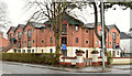
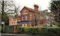
"The Hollies", Belfast
Apartments, at the corner of Cyprus Park Image (left) and the North Road Image, built (well before the boom) on the site of a large detached house and garden.
Image: © Albert Bridge
Taken: 11 Apr 2013
0.01 miles
2
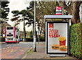
Bus shelter, Belfast (2)
Depending on location, bus shelters can be provided by councils, Translink or private enterprise. Suburban shelters are a useful medium for advertising and tend to be erected by the latter. This one is on the North Road.
Image: © Albert Bridge
Taken: 5 Mar 2012
0.03 miles
3
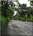
North Road, Belfast
Road in Belfast. Residential, but usually busy with traffic cutting across east Belfast, though reasonably quiet when this was taken.
Image: © Rossographer
Taken: 10 Jul 2008
0.03 miles
4
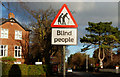
"Blind people" sign, Belfast
The RNIB has an office slightly further along the North Road. Guide dogs and their owners on (supervised) familiarisation walks are a feature locally. See also Image – December 2011.
Image: © Albert Bridge
Taken: 15 Dec 2009
0.03 miles
5
Former Blind Centre, Belfast
A large Edwardian detached house at 70 North Road, formerly the RNIB’s Blind Centre Image, now vacant and offered for sale for redevelopment. Described by the agent as “The subject property benefits from Full Planning Permission for the construction of 6no. apartments comprising 3No. 1 beds and 3No. 2 beds. Application No. Z/2009/0213/F”. At the time of construction it seems to have been the North Road Collegiate School for girls. This photograph appears as a matter of record only. I have no connection with any of the parties involved in the sale.
Image: © Albert Bridge
Taken: 31 Dec 2011
0.03 miles
6
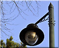
Street light, Belfast
Image: © Albert Bridge
Taken: 19 Dec 2011
0.05 miles
7
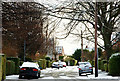
December snow, Belfast 2009-9
See Image By 11.05 Cyprus Park had only a light coating of snow. Continue to Image Image shows the street in April 2012 – without snow.
Image: © Albert Bridge
Taken: 20 Dec 2009
0.05 miles
8
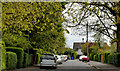
Cyprus Park, Belfast
See Image (December 2009). A late 19th century street on the eastern side of the North Road. At the turn of the last century its residents included two members of the clergy and the company secretary of the Musgrave Foundry Image
Image: © Albert Bridge
Taken: 28 Apr 2012
0.05 miles
9
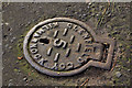
Glenfield access cover, Belfast
A Glenfield & Kennedy cover on the North Road, opposite Cyprus Gardens – similar in appearance to this anonymous example marked “Belfast Water Works” Image
Image: © Albert Bridge
Taken: 16 Nov 2011
0.06 miles
10
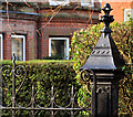
Ornamental gatepost, Belfast (1)
An ornamental cast-iron gatepost, at Cyprus Avenue, near the North Road. Image shows the maker’s name. There is an identical one in Bangor Image
Image: © Albert Bridge
Taken: 5 Jan 2012
0.06 miles