IMAGES TAKEN NEAR TO
Hollycroft Avenue, BELFAST, BT5 5JE
Introduction
This page details the photographs taken nearby to Hollycroft Avenue, BT5 5JE by members of the Geograph project.
The Geograph project started in 2005 with the aim of publishing, organising and preserving representative images for every square kilometre of Great Britain, Ireland and the Isle of Man.

There are currently over 7.5m images from over14,400 individuals and you can help contribute to the project by visiting https://www.geograph.org.uk
Image Map
Images are licensed for reuse under creativecommons.org/licenses/by-sa/2.0
Notes
- Clicking on the map will re-center to the selected point.
- The higher the marker number, the further away the image location is from the centre of the postcode.
Image Listing (193 Images Found)
Images are licensed for reuse under creativecommons.org/licenses/by-sa/2.0
Image
Details
Distance
1
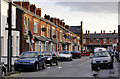
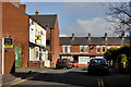
Hollycroft Avenue, Belfast
A street, built after WW1, running from the Beersbridge Road to Woodcot Avenue (background).
Image: © Albert Bridge
Taken: 19 Dec 2011
0.02 miles
2
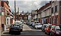
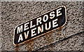
Melrose Avenue, Belfast
A street running from the Beersbridge Road to Woodcot Avenue (background). It was under construction in 1900/01. Image shows the street’s cast name sign.
Image: © Albert Bridge
Taken: 28 Apr 2012
0.03 miles
3
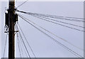
Telephone cables, Belfast
Overhead telephone wires at the Beersbridge Road end of Hollycroft Avenue Image – a not uncommon sight in east Belfast.
Image: © Albert Bridge
Taken: 19 Dec 2011
0.03 miles
4
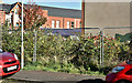
Nos 363-365 Beersbridge Road, Belfast (September 2017)
The still-vacant site, seen from Hollycroft Avenue.
Image: © Albert Bridge
Taken: 25 Sep 2017
0.03 miles
5
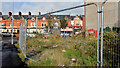
Vacant site, Beersbridge Road, Belfast (October 2012)
The view towards the Beersbridge Road.
Image: © Albert Bridge
Taken: 17 Oct 2012
0.04 miles
6
Vacant site, Beersbridge Road, Belfast (August 2013)
The site, looking from Hollycroft Avenue towards the Beersbridge Road. Buddleia is in the process of colonising it.
Image: © Albert Bridge
Taken: 14 Aug 2013
0.04 miles
7
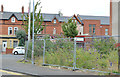
Telephone box, Bloomfield, Belfast
A telephone box, on the Beersbridge Road near Bloomfield Avenue. St Donard’s church Image is in the background to the right of the box.
Image: © Albert Bridge
Taken: 28 Apr 2012
0.04 miles
8
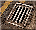
"Needham" grating cover, Belfast (3)
A grating cover, on the Beersbridge Road, opposite Melrose Avenue Image cast by J Needham & Sons Limited, Stockport http://www.geograph.org.uk/search.php?i=30879090. This one carries the number 60289.
Image: © Albert Bridge
Taken: 28 Apr 2012
0.04 miles
9
Clara Crescent Lower, Belfast (1)
A late 19th century street running from the Greenville Road to Clara Avenue (background). At the time of building it seems to have been known as “Clara Crescent” and appears to have been renamed to avoid confusion with the existing Clara Crescent Upper. Image shows the unusual name sign at the Greenville Road end.
Image: © Albert Bridge
Taken: 5 Mar 2012
0.05 miles
10
Melrose Avenue sign, Belfast
Cast sign at the Woodcot Avenue end of Melrose Avenue, off the Beersbridge Road.
Image: © Albert Bridge
Taken: 28 Mar 2011
0.06 miles