IMAGES TAKEN NEAR TO
Castlereagh Road, BELFAST, BT5 5FR
Introduction
This page details the photographs taken nearby to Castlereagh Road, BT5 5FR by members of the Geograph project.
The Geograph project started in 2005 with the aim of publishing, organising and preserving representative images for every square kilometre of Great Britain, Ireland and the Isle of Man.

There are currently over 7.5m images from over14,400 individuals and you can help contribute to the project by visiting https://www.geograph.org.uk
Image Map
Images are licensed for reuse under creativecommons.org/licenses/by-sa/2.0
Notes
- Clicking on the map will re-center to the selected point.
- The higher the marker number, the further away the image location is from the centre of the postcode.
Image Listing (96 Images Found)
Images are licensed for reuse under creativecommons.org/licenses/by-sa/2.0
Image
Details
Distance
1
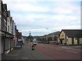
Castlereagh Road, Belfast
Looking south-east along the Castlereagh Road, east Belfast
Image: © Patrick Brown
Taken: 27 Aug 2005
0.05 miles
2
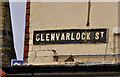
Glenvarlock Street, Belfast (3)
The tiled name sign at the Castlereagh Road end of Glenvarlock Street Image (northern side).
Image: © Albert Bridge
Taken: 19 Dec 2011
0.05 miles
3
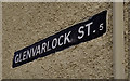
Glenvarlock Street, Belfast (2)
The white-on-black name sign at the Castlereagh Road end of Glenvarlock Street Image (southern side).
Image: © Albert Bridge
Taken: 19 Dec 2011
0.05 miles
4
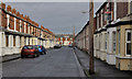
Glenvarlock Street, Belfast (1)
A late-Victorian street, of mainly architecturally-intact terrace houses, off the Castlereagh Road. Image and Image show the name signs.
Image: © Albert Bridge
Taken: 19 Dec 2011
0.06 miles
5
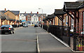
Newry Street, Belfast
A street running from Euston Street to the Castlereagh Road (background). Built in the late 19th century and now rebuilt as shown.
Image: © Albert Bridge
Taken: 16 Nov 2011
0.08 miles
6
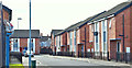
Cloverfield Street, Belfast (April 2018)
Apex Housing Association houses off Clara Street. Cloverfield Street is a completely new street built on the site of a former council yard. The name is a continuation of local botanical street names Image Image
Image: © Albert Bridge
Taken: 28 Apr 2018
0.09 miles
7
Clara Street, Belfast
A late 19th century street, running from the Castlereagh Road (behind me) to the Beersbridge Road. Now redeveloped except for this short row at the corner of Ravensdale Street (left).
Image: © Albert Bridge
Taken: 16 Nov 2011
0.10 miles
8
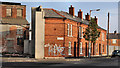
Nos 193-203 Beersbridge Road, Belfast - December 2015(2)
Outbuildings seen from the north west.
Image: © Albert Bridge
Taken: 14 Dec 2015
0.11 miles
9
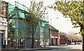
Nos 183-191 Beersbridge Road, Belfast (April 2019)
The apartments, under construction and well hidden by shadow, scaffolding and mesh.
Image: © Albert Bridge
Taken: 22 Apr 2019
0.11 miles
10
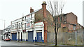
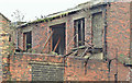
Nos 193-203 Beersbridge Road, Belfast - December 2015(1)
The buildings seen from the north west.
Image: © Albert Bridge
Taken: 14 Dec 2015
0.11 miles