IMAGES TAKEN NEAR TO
Beersbridge Road, BELFAST, BT5 5EB
Introduction
This page details the photographs taken nearby to Beersbridge Road, BT5 5EB by members of the Geograph project.
The Geograph project started in 2005 with the aim of publishing, organising and preserving representative images for every square kilometre of Great Britain, Ireland and the Isle of Man.

There are currently over 7.5m images from over14,400 individuals and you can help contribute to the project by visiting https://www.geograph.org.uk
Image Map
Images are licensed for reuse under creativecommons.org/licenses/by-sa/2.0
Notes
- Clicking on the map will re-center to the selected point.
- The higher the marker number, the further away the image location is from the centre of the postcode.
Image Listing (329 Images Found)
Images are licensed for reuse under creativecommons.org/licenses/by-sa/2.0
Image
Details
Distance
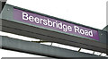
1
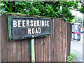
Sign, Beersbridge Road, Belfast
Street sign on the corner of the Beersbridge and Upper Newtownards Roads.
Image: © Rossographer
Taken: 10 Jul 2008
0.02 miles
2
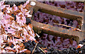
Cherry blossom and drain, Belfast
Cherry blossom seems to last for a few days before wind or rain quickly brings it to the ground and, in this case at the Beersbridge Road end of Cyprus Avenue, into a storm drain.
Image: © Albert Bridge
Taken: 29 Apr 2014
0.02 miles
3
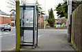
Telephone box, Belfast (26)
At the Upper Newtownards Road end of the Beersbridge Road.
Image: © Albert Bridge
Taken: 8 Apr 2013
0.03 miles
4
Beersbridge Road EWAY halt, Belfast - February 2018(1)
The inward halt, on the Upper Newtownards Road, close to the Beersbridge Road corner.
Image: © Albert Bridge
Taken: 5 Feb 2018
0.03 miles
5
Beersbridge Road EWAY halt, Belfast - February 2018(2)
The name sign.
Image: © Albert Bridge
Taken: 5 Feb 2018
0.03 miles
6
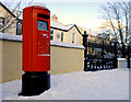
Pillar box, Belfast
EIIR pillar box, on the western side of the Beersbridge Road, near the Upper Newtownards Road.
Image: © Albert Bridge
Taken: 19 Dec 2010
0.03 miles
7
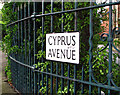
Caught one more time........
......up on Cyprus Avenue
© Van Morrison.
Street sign of the delightful Cyprus Avenue (see Image) in east Belfast, immortalised in Morrison's lyrics. See http://www.amazon.co.uk/Astral-Weeks-Van-Morrison/dp/B000002KAT/ref=sr_1_1?ie=UTF8&s=music&qid=1215594434&sr=8-1 and http://en.wikipedia.org/wiki/Cyprus_Avenue .
Image: © Rossographer
Taken: 9 Jul 2008
0.03 miles
8
EWAY works, Upper Newtownards Road, Belfast - September 2015(2)
Approaching the existing inward bus lane between the Beersbridge Road and the Holywood Arches. So far only minor work underway along the footpath.
Image: © Albert Bridge
Taken: 27 Sep 2015
0.04 miles
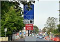
9
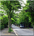
Cyprus Avenue, Belfast
Fine tree lined avenue in east Belfast. Most of the avenue lies in Image but the western end touches into Image See also Image
Image: © Rossographer
Taken: 9 Jul 2008
0.04 miles
10
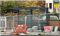
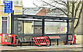
EWAY bus shelter, Belfast (October 2017)
A new Belfast Rapid Transit shelter erected, though not in yet in use, on the Upper Newtownards Road, just past Irwin Avenue. This will become a “halt” - not a “stop”.
Image: © Albert Bridge
Taken: 15 Oct 2017
0.04 miles