IMAGES TAKEN NEAR TO
Beersbridge Road, BELFAST, BT5 5DX
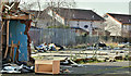
Introduction
This page details the photographs taken nearby to Beersbridge Road, BT5 5DX by members of the Geograph project.
The Geograph project started in 2005 with the aim of publishing, organising and preserving representative images for every square kilometre of Great Britain, Ireland and the Isle of Man.

There are currently over 7.5m images from over14,400 individuals and you can help contribute to the project by visiting https://www.geograph.org.uk
Image Map
Images are licensed for reuse under creativecommons.org/licenses/by-sa/2.0
Notes
- Clicking on the map will re-center to the selected point.
- The higher the marker number, the further away the image location is from the centre of the postcode.
Image Listing (191 Images Found)
Images are licensed for reuse under creativecommons.org/licenses/by-sa/2.0
Image
Details
Distance
1

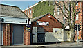
Former mill chimney, Belfast
The chimney of the former Owen O’Cork mill Image on the Beersbridge Road. The mill, engine house, office and stores are listed as HB26/10/006.
Image: © Albert Bridge
Taken: 15 Jul 2011
0.02 miles
2
Proposed social housing, Beersbridge Road, Belfast - March 2018(4)
The vacant site behind the existing buildings.
Image: © Albert Bridge
Taken: 12 Mar 2018
0.03 miles
3
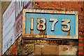
The Owen O'Cork mill, Belfast (2)
See Image The plaque showing the date of building.
Image: © Albert Bridge
Taken: 25 Jan 2010
0.03 miles
4
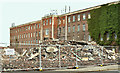
Proposed social housing, Beersbridge Road, Belfast - June 2019(1)
The vacant buildings have now been demolished leaving a temporary view through to the Owen O’Cork mill Image
Image: © Albert Bridge
Taken: 1 Jun 2019
0.04 miles
5
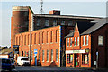
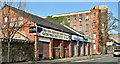
The Owen O'Cork mill, Belfast
The Owen O’Cork Mill on the Beersbridge Road. Built in 1873, it replaced a corn mill from the mid-17th century. Formerly occupied by James McCann (linen merchant) and later by the Belfast Flax & Jute Co Ltd. Long closed and now used by the usual assortment of small businesses. The street’s name comes from the De Beers who owned the original corn mill. Continue to Image
Image: © Albert Bridge
Taken: 25 Jan 2010
0.04 miles
6
Proposed social housing, Beersbridge Road, Belfast - March 2018(2)
Part of the site, from Abetta Parade.
Image: © Albert Bridge
Taken: 12 Mar 2018
0.04 miles
7
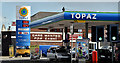
Topaz petrol station, Belfast (April 2016)
Topaz petrol station on the Beersbridge Road.
Image: © Albert Bridge
Taken: 27 Apr 2016
0.04 miles
8
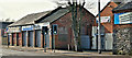
Proposed social housing, Beersbridge Road, Belfast - March 2018(1)
The site from the south west. The Owen O’Cork Mill Image is in the background.
Image: © Albert Bridge
Taken: 12 Mar 2018
0.04 miles
9
Proposed social housing, Beersbridge Road, Belfast - March 2018(3)
The view from the north east.
Image: © Albert Bridge
Taken: 12 Mar 2018
0.04 miles
10
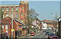
Proposed social housing, Beersbridge Road, Belfast - March 2018(5)
The view from close to the gates of Elmgrove school. The Owen O’Cork Mill Image is at top left. The site is to the left of the red car (middle bottom).
Image: © Albert Bridge
Taken: 12 Mar 2018
0.04 miles