IMAGES TAKEN NEAR TO
Lena Street, BELFAST, BT5 5BJ
Introduction
This page details the photographs taken nearby to Lena Street, BT5 5BJ by members of the Geograph project.
The Geograph project started in 2005 with the aim of publishing, organising and preserving representative images for every square kilometre of Great Britain, Ireland and the Isle of Man.

There are currently over 7.5m images from over14,400 individuals and you can help contribute to the project by visiting https://www.geograph.org.uk
Image Map
Images are licensed for reuse under creativecommons.org/licenses/by-sa/2.0
Notes
- Clicking on the map will re-center to the selected point.
- The higher the marker number, the further away the image location is from the centre of the postcode.
Image Listing (538 Images Found)
Images are licensed for reuse under creativecommons.org/licenses/by-sa/2.0
Image
Details
Distance
1
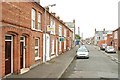
Lena Street, Belfast
A short street running down to Ravenscroft Avenue Image It was built in the late 19th century and had an end-on boundary with the old Belfast and County Down Railway to Donaghadee and Newcastle (behind me).
Image: © Albert Bridge
Taken: 16 Jun 2009
0.01 miles
2
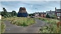
Chobham Street Bonfire Belfast
Chobham Street bonfire East Belfast
Made from wooden pallets and car tyres this bonfire created a lot of media attention when homes were boarded up or evacuated prior to the lighting on the 12th of July at 00.07
Image: © John Thompson
Taken: 10 Jul 2015
0.03 miles
3
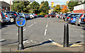
Car park cycle lane, Belfast
National Cycle Route no 99 Image, crossing the Ravenscroft Avenue car park, between the Beersbridge Road and the Holywood Arches.
Image: © Albert Bridge
Taken: 15 Oct 2012
0.03 miles
4
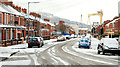
December snow, Belfast 2009-6
See Image At 10.35, the snow on the ground in Ravenscroft Avenue Image was being worn by the passing traffic. The view is towards the Newtownards Road with the library Image below the Harland & Wolff cranes. Continue to Image
Image: © Albert Bridge
Taken: 20 Dec 2009
0.04 miles
5
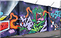
Car park graffiti, Belfast
Graffiti at the car park in Ravenscroft Avenue.
Image: © Albert Bridge
Taken: 3 Jan 2014
0.04 miles
6
Finvoy Street, Belfast (1)
An irregularly-shaped street, built towards the end of the 19th century, Finvoy Street runs south south west and then south east off the Upper Newtownards Road. Its line was probably dictated by the existing Belfast and County Down Railway which ran along what is now the stretch of grass in the middle of the photo. This is the part of the street at the Upper Newtownards Road end. See also Image
Image: © Albert Bridge
Taken: 29 Jul 2009
0.05 miles
7
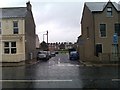
View into Finvoy Street from Newtownards Road
Image: © David Martin
Taken: 16 Oct 2013
0.05 miles
8
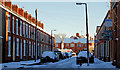
Ravenscroft Street, Belfast
A street, built towards the end of the 19th century, running from Bloomfield Avenue to Ravenscroft Avenue (background). In common with any street not receiving direct sunlight, it was covered in treacherous frozen snow.
Image: © Albert Bridge
Taken: 19 Dec 2010
0.05 miles
9
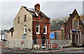
Fire-damaged house, Belfast
A house, recently damaged by fire, at the corner of Finvoy Street Image (left) and the Upper Newtownards Road. Bloomfield Baptist church Image is on the right. Image shows the house under restoration in June 2012.
Image: © Albert Bridge
Taken: 29 Oct 2011
0.06 miles
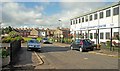
10
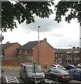
Housing estate on redeveloped land between Upper Newtownards Road and Ravenscroft Avenue
Image: © Eric Jones
Taken: 26 Jun 2017
0.06 miles