IMAGES TAKEN NEAR TO
Mill Park, PORTSTEWART, BT55 7RG
Introduction
This page details the photographs taken nearby to Mill Park, BT55 7RG by members of the Geograph project.
The Geograph project started in 2005 with the aim of publishing, organising and preserving representative images for every square kilometre of Great Britain, Ireland and the Isle of Man.

There are currently over 7.5m images from over14,400 individuals and you can help contribute to the project by visiting https://www.geograph.org.uk
Image Map
Images are licensed for reuse under creativecommons.org/licenses/by-sa/2.0
Notes
- Clicking on the map will re-center to the selected point.
- The higher the marker number, the further away the image location is from the centre of the postcode.
Image Listing (3 Images Found)
Images are licensed for reuse under creativecommons.org/licenses/by-sa/2.0
Image
Details
Distance
1
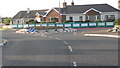
Mill Road Roundabout
A small roundabout which bikers negotiate anti-clockwise.The temporary keep-left sign is for us ordinary mortals.Image
Image: © Willie Duffin
Taken: 16 May 2008
0.22 miles
2
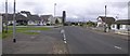
Portstewart, County Derry / Londonderry
Pictured in the Mullaghmacall district of the town and heading towards the strand. Lots of student accommodation and holiday homes round here.
Image: © Kenneth Allen
Taken: 15 Aug 2007
0.22 miles
3
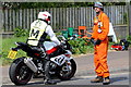
Safety men at the Northwest 200
The marshal on the motorbike checks the conditions on the roads prior to, during, and post race. His static colleague holds the spectators out of harm's way and should the need arise enables ambulances and emergency vehicles access to the track.
Image: © Des Colhoun
Taken: 11 May 2017
0.25 miles