IMAGES TAKEN NEAR TO
Burnside Road, PORTSTEWART, BT55 7NS
Introduction
This page details the photographs taken nearby to Burnside Road, BT55 7NS by members of the Geograph project.
The Geograph project started in 2005 with the aim of publishing, organising and preserving representative images for every square kilometre of Great Britain, Ireland and the Isle of Man.

There are currently over 7.5m images from over14,400 individuals and you can help contribute to the project by visiting https://www.geograph.org.uk
Image Map
Images are licensed for reuse under creativecommons.org/licenses/by-sa/2.0
Notes
- Clicking on the map will re-center to the selected point.
- The higher the marker number, the further away the image location is from the centre of the postcode.
Image Listing (6 Images Found)
Images are licensed for reuse under creativecommons.org/licenses/by-sa/2.0
Image
Details
Distance
1
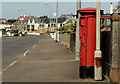
Pillar box, Portstewart
EIIR pillar box (BT55 114) on the Strand Road.
Image: © Albert Bridge
Taken: 4 Sep 2012
0.10 miles
2
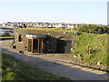
House at Portstewart
This modern house is built into the side of the bank facing the sea, it has a grass roof.
Image: © Kenneth Allen
Taken: 18 May 2005
0.12 miles
3
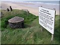
St Patrick's Well (Tubberpatrick), Portstewart
It is located on the path leaving the road to Portstewart Strand, opposite the Golf Club. The sign reads, "St Patrick's Well, Strand Head, Portstewart. Tobber Patrick or St Patrick's well was probably a pagan sacred well before Christianity came to Ireland. Pilgrimages were made to the Well and in time those developed into an Annual Fair held on the last Monday of August with races, etc on the Strand. The well would have been the source of water for the prehistoric inhabitants of the nearby sand dunes."
Image: © Kenneth Allen
Taken: 23 May 2008
0.22 miles
4
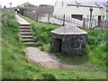
Tubber Patrick (St Patrick's Well)
St Patrick's Well at the end of Portstewart strand was thought to be the fresh water supply for the Stone Age inhabitants of the sand hills. It was used as a source of holy water by the inhabitants of Portstewart, and locals sold the water to tourists until the 1940's.
Image: © Kenneth Allen
Taken: 23 May 2008
0.22 miles
5
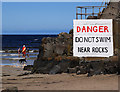
Warning sign, Portstewart
Warning sign at the eastern end of Portstewart Strand. The RNLI lifeguard seen in Image is talking to two youngsters who have failed to heed the warning.
Image: © Rossographer
Taken: 23 Jul 2011
0.23 miles
6

Portstewart Strand
Pictured near East Crossreagh
Image: © Kenneth Allen
Taken: 23 May 2008
0.24 miles