IMAGES TAKEN NEAR TO
West Park, PORTSTEWART, BT55 7NA
Introduction
This page details the photographs taken nearby to West Park, BT55 7NA by members of the Geograph project.
The Geograph project started in 2005 with the aim of publishing, organising and preserving representative images for every square kilometre of Great Britain, Ireland and the Isle of Man.

There are currently over 7.5m images from over14,400 individuals and you can help contribute to the project by visiting https://www.geograph.org.uk
Image Map
Images are licensed for reuse under creativecommons.org/licenses/by-sa/2.0
Notes
- Clicking on the map will re-center to the selected point.
- The higher the marker number, the further away the image location is from the centre of the postcode.
Image Listing (108 Images Found)
Images are licensed for reuse under creativecommons.org/licenses/by-sa/2.0
Image
Details
Distance
1
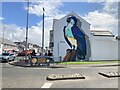
Large bird mural, Portstewart
Pictured at the start of Strand Road
Image: © Kenneth Allen
Taken: 7 Aug 2021
0.10 miles
2
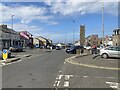
Coleraine Road, Portstewart
Heading NNW towards The Diamond
Image: © Kenneth Allen
Taken: 7 Aug 2021
0.10 miles
3
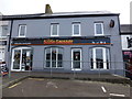
The Sizzlin Sausage, Portstewart
Pictured at the end of The Promenade
Image: © Kenneth Allen
Taken: 22 May 2015
0.11 miles
4
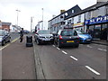
A tight squeeze, Portstewart
Mirrors retracted to get past?
Image: © Kenneth Allen
Taken: 22 May 2015
0.11 miles
5
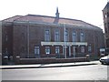
Portstewart Townhall
It has been re-furbished recently.
Image: © Kenneth Allen
Taken: 2 Apr 2007
0.12 miles
6
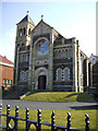
St Mary's, Star of the Sea RC Church, Portstewart
It is along the sea front.
Image: © Kenneth Allen
Taken: 2 Apr 2007
0.12 miles
7

Bench Mark 1008, Portstewart
Flush bracket bench mark, it is located here Image
The number on the bracket is OSNIBM 1008.
The mark is 14.00 metres above MSL.
OSNI produced an initial run of flush brackets numbered 1001-1025 that were used c1932-1936; of these, 21 were sited in the greater Belfast area and 4 in County Londonderry. This is the only remaining bracket from the 4 located outside Belfast still in existence - the other 3 were all sited in the Toome area but have been destroyed. OSNI later used flush brackets in much greater numbers for the retriangulation and levelling of Northern Ireland in the 1950s and early 1960s. See also Image
Image: © Kenneth Allen
Taken: 18 Aug 2010
0.12 miles
8
Seaside properties, Portstewart
A surveyor with a clipboard is taking notes
Image: © Kenneth Allen
Taken: 21 Aug 2012
0.12 miles
9

Agherton Church of Ireland, Portstewart
It is in the Diocese of Connor
My attention was drawn to the bench mark here Image]
Image: © Kenneth Allen
Taken: 18 Aug 2010
0.13 miles
10

Bench mark, Agherton Church
Image: © Kenneth Allen
Taken: 18 Aug 2010
0.13 miles