IMAGES TAKEN NEAR TO
Strandview Avenue, PORTSTEWART, BT55 7LL
Introduction
This page details the photographs taken nearby to Strandview Avenue, BT55 7LL by members of the Geograph project.
The Geograph project started in 2005 with the aim of publishing, organising and preserving representative images for every square kilometre of Great Britain, Ireland and the Isle of Man.

There are currently over 7.5m images from over14,400 individuals and you can help contribute to the project by visiting https://www.geograph.org.uk
Image Map
Images are licensed for reuse under creativecommons.org/licenses/by-sa/2.0
Notes
- Clicking on the map will re-center to the selected point.
- The higher the marker number, the further away the image location is from the centre of the postcode.
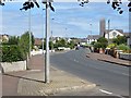
Image Listing (3 Images Found)
Images are licensed for reuse under creativecommons.org/licenses/by-sa/2.0
Image
Details
Distance
1
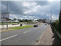
Burnside Roundabout
The A2, Portstewart.
Image: © Richard Webb
Taken: 4 Aug 2013
0.17 miles
3
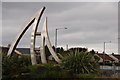
The Burnside roundabout, Portstewart
This is the Burnside roundabout on the Coleraine Road, Portstewart. The sculpture represents the “Red Sails in the Sunset” from the song of the same name.
Image: © Albert Bridge
Taken: 31 Aug 2006
0.20 miles