IMAGES TAKEN NEAR TO
Newlands Crescent, PORTSTEWART, BT55 7JJ
Introduction
This page details the photographs taken nearby to Newlands Crescent, BT55 7JJ by members of the Geograph project.
The Geograph project started in 2005 with the aim of publishing, organising and preserving representative images for every square kilometre of Great Britain, Ireland and the Isle of Man.

There are currently over 7.5m images from over14,400 individuals and you can help contribute to the project by visiting https://www.geograph.org.uk
Image Map
Images are licensed for reuse under creativecommons.org/licenses/by-sa/2.0
Notes
- Clicking on the map will re-center to the selected point.
- The higher the marker number, the further away the image location is from the centre of the postcode.
Image Listing (3 Images Found)
Images are licensed for reuse under creativecommons.org/licenses/by-sa/2.0
Image
Details
Distance
1
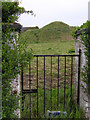
Entrance, Ancient Site, Portsewart
It is located down a lane-way near the church ruin on the Coleraine Road.
Image: © Kenneth Allen
Taken: 23 May 2008
0.20 miles
2
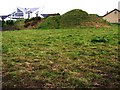
Ancient Burial Site, Portstewart
On the map this mound is indicated as a chambered grave. Here are the remains of a court grave (c.3500 B.C.) and an ancient signalling mound.
Image: © Kenneth Allen
Taken: 23 May 2008
0.20 miles
3
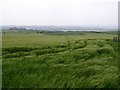
Portstewart County Derry / Londonderry
Looking WSW
Image: © Kenneth Allen
Taken: 23 May 2008
0.20 miles