IMAGES TAKEN NEAR TO
Lever Park, PORTSTEWART, BT55 7ES
Introduction
This page details the photographs taken nearby to Lever Park, BT55 7ES by members of the Geograph project.
The Geograph project started in 2005 with the aim of publishing, organising and preserving representative images for every square kilometre of Great Britain, Ireland and the Isle of Man.

There are currently over 7.5m images from over14,400 individuals and you can help contribute to the project by visiting https://www.geograph.org.uk
Image Map
Images are licensed for reuse under creativecommons.org/licenses/by-sa/2.0
Notes
- Clicking on the map will re-center to the selected point.
- The higher the marker number, the further away the image location is from the centre of the postcode.
Image Listing (2 Images Found)
Images are licensed for reuse under creativecommons.org/licenses/by-sa/2.0
Image
Details
Distance
1
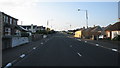
Station Road
Leaving York and heading up Station road towards the roundabout at Mill Road.Image
Image: © Willie Duffin
Taken: 16 May 2008
0.23 miles
2
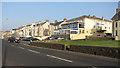
The York Hotel
The recently refurbished York hotel enjoying the late evening sun.
Image: © Willie Duffin
Taken: 7 May 2008
0.25 miles