IMAGES TAKEN NEAR TO
Heatherbell Street, BELFAST, BT5 4SP
Introduction
This page details the photographs taken nearby to Heatherbell Street, BT5 4SP by members of the Geograph project.
The Geograph project started in 2005 with the aim of publishing, organising and preserving representative images for every square kilometre of Great Britain, Ireland and the Isle of Man.

There are currently over 7.5m images from over14,400 individuals and you can help contribute to the project by visiting https://www.geograph.org.uk
Image Map
Images are licensed for reuse under creativecommons.org/licenses/by-sa/2.0
Notes
- Clicking on the map will re-center to the selected point.
- The higher the marker number, the further away the image location is from the centre of the postcode.
Image Listing (152 Images Found)
Images are licensed for reuse under creativecommons.org/licenses/by-sa/2.0
Image
Details
Distance
1
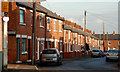
Heatherbell Street, Belfast
A street of late 19th century houses off the Beersbridge Road.
Image: © Albert Bridge
Taken: 25 Jan 2010
0.00 miles
2
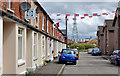
Foxglove Street, Belfast
A late 19th century street off the Beersbridge Road. One side retains the original terrace houses. The other has been redeveloped. Several streets, on this side of the road, have “flowery” names.
Image: © Albert Bridge
Taken: 15 Jul 2011
0.02 miles
3
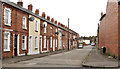
Flora Street, Belfast
A late 19th century street running from Mayflower Street Image to the Beersbridge Road (background).
Image: © Albert Bridge
Taken: 22 Aug 2011
0.02 miles
4
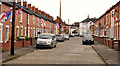
Mayflower Street, Belfast
A late 19th century street running from Flora Street Image to the Beersbridge Road (background).
Image: © Albert Bridge
Taken: 22 Aug 2011
0.03 miles
5
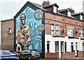
Polish servicemen mural, Foxglove Street, Belfast (February 2017)
See Image A recently-painted mural at the Beersbridge Road end of Foxglove Street Image It commemorates the Poles who have served in HM forces.
Image: © Albert Bridge
Taken: 25 Feb 2017
0.03 miles
6
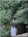
River Connswater, Belfast
The River Connswater seen from the Beersbridge Road, Belfast
Image: © Patrick Brown
Taken: 27 Aug 2005
0.05 miles
7
Nos 211-217 Beersbridge Road, Belfast - June 2018(1)
The fenced site with some work done on the foundations - Beersbridge Road is on the right.
Image: © Albert Bridge
Taken: 15 Jun 2018
0.06 miles
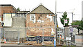
8
Nos 211-217 Beersbridge Road, Belfast - June 2018(2)
The view, from the Beersbridge Road, towards Clara Street.
Image: © Albert Bridge
Taken: 15 Jun 2018
0.06 miles
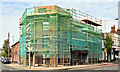
9
Nos 211-217 Beersbridge Road, Belfast (April 2019)
The Clara Street side of the site.
Image: © Albert Bridge
Taken: 22 Apr 2019
0.06 miles
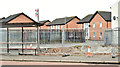
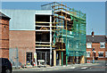
10
Nos 211-217 Beersbridge Road, Belfast (May 2019)
The Beersbridge Road side with an externally-complete building hidden by scaffolding and mesh.
Image: © Albert Bridge
Taken: 12 May 2019
0.06 miles