IMAGES TAKEN NEAR TO
Albertbridge Road, BELFAST, BT5 4PY
Introduction
This page details the photographs taken nearby to Albertbridge Road, BT5 4PY by members of the Geograph project.
The Geograph project started in 2005 with the aim of publishing, organising and preserving representative images for every square kilometre of Great Britain, Ireland and the Isle of Man.

There are currently over 7.5m images from over14,400 individuals and you can help contribute to the project by visiting https://www.geograph.org.uk
Image Map
Images are licensed for reuse under creativecommons.org/licenses/by-sa/2.0
Notes
- Clicking on the map will re-center to the selected point.
- The higher the marker number, the further away the image location is from the centre of the postcode.
Image Listing (357 Images Found)
Images are licensed for reuse under creativecommons.org/licenses/by-sa/2.0
Image
Details
Distance
1
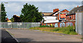
Skipton Street, Belfast
Currently vacant site, at Skipton Street and Carnforth Street, for which planning permission has been sought for “Land at junction of Skipton Street and Carnforth Street, Belfast. Construction of 7 dwellings with private gardens”.
Image shows the street (still undeveloped) in November 2011.
Image: © Albert Bridge
Taken: 27 Jun 2010
0.02 miles
2
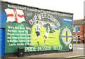
Football mural, Belfast (1)
Self-explanatory mural, on a wall, in Carnforth Street, off the Albertbridge Road (background). Continue to Image Subsequently replaced by Image
Image: © Albert Bridge
Taken: 22 Jul 2009
0.02 miles
3
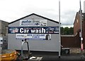
Autoclinic and Albert Bridge Car Wash and Valet Centre in Albertbridge Road
Image: © Eric Jones
Taken: 26 Jun 2017
0.02 miles
4
Skipton Street, Belfast (2)
See Image (June 2010). My understanding is that the proposed development, of new houses on, this site was approved. So far there is no sign of any work.
Image: © Albert Bridge
Taken: 8 Nov 2011
0.02 miles
5
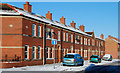
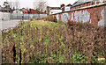
Hornby Street, Belfast (1)
Hornby Street seems to have been developed some time before 1877. It ran (and still does) from the Albertbridge Road to the Newtownards Road. This part (western side) was redeveloped relatively recently in a modern style in keeping with tradition. See also Image
Image: © Albert Bridge
Taken: 19 Dec 2010
0.03 miles
6
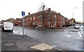
Hornby Road at its junction with Albertbridge Road (A20)
Image: © Eric Jones
Taken: 3 Nov 2014
0.03 miles
7
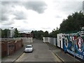
The entrance to the Thompson's Family Teas Factory in Carnforth Street
Thompsons have been producing a range of teas in Belfast since 1896.
http://punjana.com/about-us/why-pick-punjana/
Image: © Eric Jones
Taken: 26 Jun 2017
0.03 miles
8
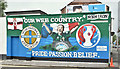
Northern Ireland (Euro 2016) football mural, Belfast (June 2016)
See Image (July 2009). The previous mural, at the Albertbridge Road end of Carnforth Street, did not weather well and had peeled badly. This is the replacement, just unveiled in time for the Euro 2016 matches. See also https://www.youtube.com/watch?v=EL2YD2mLTCk.
Image: © Albert Bridge
Taken: 11 Jun 2016
0.04 miles
9
No 279 Albertbridge Road, Belfast (August 2015)
The former Kingswood Pigeon Club, now vacant and semi derelict, with a “sold” patch on the agents’ “for sale” sign. It seems likely to join Image as a regeneration site. Image (since re-named) is on the left.
Image: © Albert Bridge
Taken: 16 Aug 2015
0.04 miles
10
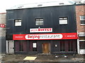
Beijing Restaurant in Albert Bridge Road, East Belfast
The pavement is being reconstructed.
Image: © Eric Jones
Taken: 26 Jun 2017
0.05 miles