IMAGES TAKEN NEAR TO
Albertbridge Road, BELFAST, BT5 4PS
Introduction
This page details the photographs taken nearby to Albertbridge Road, BT5 4PS by members of the Geograph project.
The Geograph project started in 2005 with the aim of publishing, organising and preserving representative images for every square kilometre of Great Britain, Ireland and the Isle of Man.

There are currently over 7.5m images from over14,400 individuals and you can help contribute to the project by visiting https://www.geograph.org.uk
Image Map
Images are licensed for reuse under creativecommons.org/licenses/by-sa/2.0
Notes
- Clicking on the map will re-center to the selected point.
- The higher the marker number, the further away the image location is from the centre of the postcode.
Image Listing (232 Images Found)
Images are licensed for reuse under creativecommons.org/licenses/by-sa/2.0
Image
Details
Distance
1
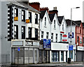
Nos 147 & 153 Albertbridge Road, Belfast (April 2016)
Two vacant properties, at the south western end of the Albertbridge Road, offered for sale by separate agents. Described by them as (147) “The property will be suitable for owner occupiers or investors Upper floors may be suitable for conversion to residential use subject to obtaining the necessary statutory consents Heating is provided by way of an oil fired central heating system”.
153 “Mid terrace property with redevelopment potential subject to any necessary consents. Occupies a prominent position on one of Belfast’s main arterial routes. Extending to approximately 1,174 sqft.”
I have no connection with any of the parties involved in the sales.
Image: © Albert Bridge
Taken: 13 Apr 2016
0.00 miles
2
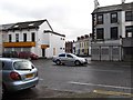
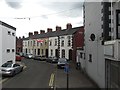
The Stormont Street junction on Albertbridge Road
Image: © Eric Jones
Taken: 3 Nov 2014
0.01 miles
3
View east along Albertbridge Road
The white car in the middle distance is emerging out of Cluan Place.
Image]
Image: © Eric Jones
Taken: 3 Nov 2014
0.01 miles
4
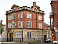
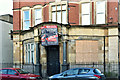
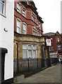
Former Ulster Bank (Mountpottinger Branch), Belfast
See Image The former Mountpottinger branch of the Ulster Bank at 148 Albertbridge Road (corner of Cluan Place – at the black car). It was built in 1908/10 to a design by Blackwood and Jury who later designed the Connswater branch. This branch closed in 1998 when amalgamated with Connswater. Before its construction the branch, managed by one MW Blackwood, had been at no 150 (part of the building on the right). Currently vacant. Continue to Image
Image: © Albert Bridge
Taken: 13 Nov 2013
0.01 miles
5
Former Ulster Bank, Albertbridge Road, Belfast (November 2018)
See Image (November 2013) and Image (November 2014). Now with a “sold” patch on the “for sale” sign. The agents’ description included “This is a superb opportunity to acquire a handsome and historically significant property in a central location within walking distance of Belfast City Centre . . . . . . . In recent years the property has been sympathetically converted into modern offices on the upper floors and offer a great investment opportunity so close to the City Centre. The ground floor of the former Ulster Bank building is around 2,000 sq ft making this a sizable [sic] property suitable for a number of differing requirements. Many of the internal and external features from the bank can be found including the vault providing excellent security for files and documentation”.
I have no connection with the property or sale and cannot enter into correspondence.
Image: © Albert Bridge
Taken: 20 Nov 2018
0.01 miles
6
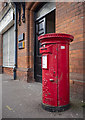
Pillar box, Belfast
Elizabeth II postbox (BT5 269D) on the Albertbridge Road, Belfast. Last seen in Image Of note is that the box is fitted with an aperture reducing plate - these were once common in Northern Ireland to prevent parcel bombs but are rare now. See https://www.flickr.com/photos/peterdenton/2246315851/ for a related image and explanation - a cast iron pillar box can be a lethal weapon. See also Image
Image: © Rossographer
Taken: 22 Sep 2020
0.02 miles
7
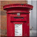
Pillar box, Belfast
Elizabeth II postbox (BT5 269D) on the Albertbridge Road, Belfast Image Of note is that the box is fitted with an aperture reducing plate - these were once common in Northern Ireland to prevent parcel bombs but are rare now. See https://www.flickr.com/photos/peterdenton/2246315851/ for a related image and explanation - a cast iron pillar box can be a lethal weapon.
Image: © Rossographer
Taken: 22 Sep 2020
0.02 miles
8
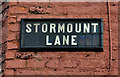
Stormount Lane, Belfast (2)
See Image The tiled name sign at the Albertbridge Road end. For an explanation of the spelling see Image
Image: © Albert Bridge
Taken: 16 Nov 2011
0.02 miles
9
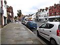
The Loyalist Stormount Lane
This cul de sac leads in from Albert Bridge Road.
Image: © Eric Jones
Taken: 26 Jun 2017
0.02 miles
10
Former Ulster Bank building now for let as office space
This prestigious landmark building is located at the junction of Albertbridge Road and Cluan Place.
Image
Image: © Eric Jones
Taken: 3 Nov 2014
0.02 miles