IMAGES TAKEN NEAR TO
Erskine Street, BELFAST, BT5 4HW
Introduction
This page details the photographs taken nearby to Erskine Street, BT5 4HW by members of the Geograph project.
The Geograph project started in 2005 with the aim of publishing, organising and preserving representative images for every square kilometre of Great Britain, Ireland and the Isle of Man.

There are currently over 7.5m images from over14,400 individuals and you can help contribute to the project by visiting https://www.geograph.org.uk
Image Map
Images are licensed for reuse under creativecommons.org/licenses/by-sa/2.0
Notes
- Clicking on the map will re-center to the selected point.
- The higher the marker number, the further away the image location is from the centre of the postcode.
Image Listing (309 Images Found)
Images are licensed for reuse under creativecommons.org/licenses/by-sa/2.0
Image
Details
Distance
1
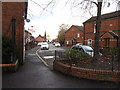
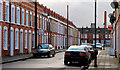
Belvoir Street, Belfast
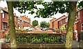
Belvoir Street displays an interesting mix of terrace architecture. There are traditional terrace houses (middle right) similar to its near neighbour McMaster Street Image (although Belvoir Street was built some 25 years earlier). In the background are the modern houses from the late 20th century. On the left and on the right (nearest the camera) are the type built by Belfast Corporation to replace houses destroyed during by the Luftwaffe during WWII.
Image: © Albert Bridge
Taken: 27 Feb 2010
0.05 miles
2
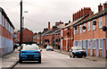
The eastern end of Major Street, Ballymacarrett
The T-junction with Belvoir Street can be seen in the background. These back to back houses were built to house the workers of the Harland and Wolff Yard.
Image: © Eric Jones
Taken: 3 Nov 2014
0.06 miles
3
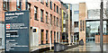
Skainos Square, Belfast (March 2018)
The entrance to the Skainos Centre Image
Image: © Albert Bridge
Taken: 11 Mar 2018
0.07 miles
4
Glenallen Street, Belfast
Rebuilt street, running from the Albertbridge Road (behind me) through to Belvoir Street and the Newtownards Road.
Image: © Albert Bridge
Taken: 4 Aug 2009
0.07 miles
5
Sam Thompson plaque, Belfast
Plaque commemorating Sam Thompson, a local playwright http://www.ulsterhistory.co.uk/Thompsonsam.html, at Vicarage Street/Montrose Street South off the Albertbridge Road.
Image: © Albert Bridge
Taken: 6 Feb 2011
0.08 miles
6
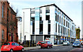
The Skainos Centre, Belfast (February 2015)
The Skainos Centre http://www.ebm.org.uk/skainos/, 239 Newtownards Road, part of the East Belfast Mission, opened in November 2012. Built (if my memory is correct) on a site which included the old Holmes Cash and Carry. The architects were Donnelly O’Neill http://www.d-on.co.uk/.
Image: © Albert Bridge
Taken: 19 Feb 2015
0.08 miles
7
The Megain Memorial Church of the Nazarene, Newtownards Road
This is a former Presbyterian church which was declared redundant and was taken over by the Church of the Nazarene in 1991. The Church of the Nazareen originated in America and is closely akin in its Arminian theology to the Wesleyan Methodism.
Image: © Eric Jones
Taken: 3 Nov 2014
0.08 miles
8
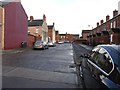
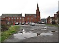
McMaster Street, Belfast
A street of terrace houses (built at the very end of the 19th century) running from the Newtownards Road to Major Street (background). One of the few streets not redeveloped, it is now listed but some of the houses are on the “at risk” register. Note for genealogists – this is not the same place as McMaster’s Court. It was off Millfield, on the other side of the Lagan.
Image: © Albert Bridge
Taken: 27 Feb 2010
0.08 miles
9
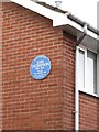
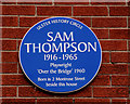
Blue Plaque commemorating the Belfast Protestant Working-Class Playwright Sam Thompson
This has been erected besides the site of the house No2 Montrose Street South in which Sam Thompson (1916-1965) was born. A ship yard worker Sam Thompson was a Socialist. His most famous play is "Over the Bridge" (1960) a controversial anti-sectarian play which was staged in Belfast against much opposition by the late Jimmy Ellis. During its six-week run in the city it attracted a greater audience number than any other play staged in Belfast before or since.
http://www.finboroughtheatre.co.uk/productions/2013/over-the-bridge.php
Image: © Eric Jones
Taken: 3 Nov 2014
0.08 miles