IMAGES TAKEN NEAR TO
Rotterdam Court, BELFAST, BT5 4DT
Introduction
This page details the photographs taken nearby to Rotterdam Court, BT5 4DT by members of the Geograph project.
The Geograph project started in 2005 with the aim of publishing, organising and preserving representative images for every square kilometre of Great Britain, Ireland and the Isle of Man.

There are currently over 7.5m images from over14,400 individuals and you can help contribute to the project by visiting https://www.geograph.org.uk
Image Map
Images are licensed for reuse under creativecommons.org/licenses/by-sa/2.0
Notes
- Clicking on the map will re-center to the selected point.
- The higher the marker number, the further away the image location is from the centre of the postcode.
Image Listing (2407 Images Found)
Images are licensed for reuse under creativecommons.org/licenses/by-sa/2.0
Image
Details
Distance
1

Laganview Mews, Belfast (2)
See Image The same street, from almost the same place, but looking in the direction of the Laganside Walkway Image and the Queen’s Bridge Image
Image: © Albert Bridge
Taken: 22 Jul 2009
0.00 miles
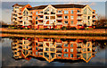
2
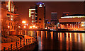
Gregg's Quay, Belfast
Gregg’s Quay runs from the end of the Queen’s Bridge along the eastern side of the River Lagan. It was one of the first developments in the “Laganside” project as well as starting the return to living in the centre of Belfast. The footbridge across the Lagan is visible at lower right.
Continue to Image
Image: © Albert Bridge
Taken: 25 Apr 2007
0.02 miles
3
Apartments by Queen's Bridge, Belfast
View across the River Lagan from the quay by the Waterfront Hall. The end of Queen's Bridge is on the left of the photo.
Image: © David Hawgood
Taken: 31 Aug 2009
0.02 miles
4
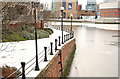
The Lagan Walkway, Belfast (3)
See Image The section of the walkway, at Gregg’s Quay (seen in Image), with a coating of compacted snow. The frozen Lagan is on the right. Continue to Image
Image: © Albert Bridge
Taken: 10 Jan 2010
0.02 miles
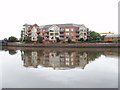
5
Gregg's Quay, Belfast (2)
See Image The Gregg’s Quay apartments basking in the warm late-afternoon winter sun. The view is from Lanyon Quay near the Waterfront Hall.
Image: © Albert Bridge
Taken: 13 Feb 2010
0.02 miles
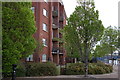
6

Rotterdam Court, Belfast
A well-designed street of social housing immediately west of Rotterdam Street Image
Image: © Albert Bridge
Taken: 22 Jul 2009
0.02 miles
7
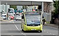
Eastside park and ride bus, Belfast (August 2015)
See Image Seven days later the Eastside park and ride service is now being worked by an Optare Versa (1810 TFZ 8810) running inward along Bridge End.
Image: © Albert Bridge
Taken: 11 Aug 2015
0.03 miles
8
The Lagan Walkway, Belfast (5)
Image: © Albert Bridge
Taken: 20 Jan 2010
0.03 miles
9
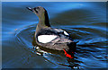
Black guillemot, River Lagan, Belfast
See Image Black guillemots are now common around Belfast harbour and the Lagan. Despite all the rebuilding work there still seems to be enough holes left for their nests. This one was in the Lagan, off Gregg’s Quay, close to the Queen’s Bridge. Continue to Image
Image: © Albert Bridge
Taken: 18 Mar 2011
0.03 miles
10
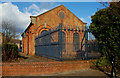
Pumping station, Belfast
The area between Gregg’s Quay Image and the western end of Bridge End Image has been redeveloped but the pumping station at Laganview Mews Image remains in use.
Image: © Albert Bridge
Taken: 13 Feb 2010
0.03 miles