IMAGES TAKEN NEAR TO
Short Strand, BELFAST, BT5 4BL
Introduction
This page details the photographs taken nearby to Short Strand, BT5 4BL by members of the Geograph project.
The Geograph project started in 2005 with the aim of publishing, organising and preserving representative images for every square kilometre of Great Britain, Ireland and the Isle of Man.

There are currently over 7.5m images from over14,400 individuals and you can help contribute to the project by visiting https://www.geograph.org.uk
Image Map
Images are licensed for reuse under creativecommons.org/licenses/by-sa/2.0
Notes
- Clicking on the map will re-center to the selected point.
- The higher the marker number, the further away the image location is from the centre of the postcode.
Image Listing (278 Images Found)
Images are licensed for reuse under creativecommons.org/licenses/by-sa/2.0
Image
Details
Distance
1
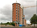
Pottinger's Quay, Belfast (8)
See Image All the protective material has been removed allowing the building to be appreciated. The architects are the Boyd Partnership. Continue to Image
Image: © Albert Bridge
Taken: 17 Aug 2009
0.02 miles
2
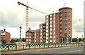
Pottinger's Quay, Belfast (9)
See Image The western side of the development seen from the Albert Bridge. Image shows the building after completion.
Image: © Albert Bridge
Taken: 17 Aug 2009
0.02 miles
3
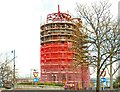
Pottinger's Quay, Belfast (5)
See Image There has been substantial progress in the four months since the last photo. The new brickwork is partly concealed behind the safety mesh. Continue to Image
Image: © Albert Bridge
Taken: 12 Apr 2009
0.03 miles
4
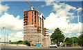
Pottingers Quay, Belfast (7)
See Image At last – a decent view of the building now that much of the scaffolding and safety mesh has been removed. Continue to Image
Image: © Albert Bridge
Taken: 22 Jul 2009
0.03 miles
5
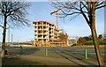
Pottinger's Quay, Belfast (3)
See Image In the two months since the previous photo, the building is now too tall for the same view. This one is from the Albertbridge Road with Short Strand to the right of the site. Continue to Image
Image: © Albert Bridge
Taken: 16 Nov 2008
0.03 miles
6
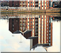
Pottinger's Quay, Belfast (11)
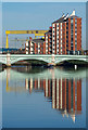
See Image The building reflected in the calm water of the River Lagan. Continue to Image (October 2013).
Image: © Albert Bridge
Taken: 13 Feb 2010
0.03 miles
7
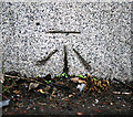
Bench Mark, Belfast
Cut bench mark located on the extreme north-eastern tip of the Albert Bridge in Belfast Image
The mark is 4.92 metres above MSL.
See also http://www.geograph.org.uk/search.php?i=11037856 for many other examples I have found.
Image: © Rossographer
Taken: 31 Mar 2010
0.03 miles
8
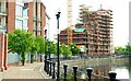
Pottinger's Quay, Belfast
See Image The development seen from the Lagan Walkway Image This view gives a better impression of the progress on the brickwork. Continue to Image
Image: © Albert Bridge
Taken: 10 May 2009
0.03 miles
9
Pottinger's Quay, Belfast
Recently constructed apartments at Pottinger's Quay http://www.geograph.org.uk/search.php?i=17050145 in Belfast, which are reflected in the calm River Lagan. The Albert Bridge is in the foreground Image and the small workboat 'Buster Crabb' http://www.geograph.org.uk/search.php?i=17050337 can just be seen emerging in front of the bridge as it heads upstream. The yellow gantry cranes 'Samson' and 'Goliath' http://www.geograph.org.uk/search.php?i=17050329 can be seen in the background.
Image: © Rossographer
Taken: 19 Nov 2010
0.03 miles
10
Albert Bridge
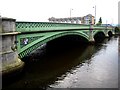
The Albert Bridge over the river Lagan
Image: © Rossographer
Taken: 18 Jun 2007
0.03 miles