IMAGES TAKEN NEAR TO
Laganview Court, BELFAST, BT5 4AR
Introduction
This page details the photographs taken nearby to Laganview Court, BT5 4AR by members of the Geograph project.
The Geograph project started in 2005 with the aim of publishing, organising and preserving representative images for every square kilometre of Great Britain, Ireland and the Isle of Man.

There are currently over 7.5m images from over14,400 individuals and you can help contribute to the project by visiting https://www.geograph.org.uk
Image Map
Images are licensed for reuse under creativecommons.org/licenses/by-sa/2.0
Notes
- Clicking on the map will re-center to the selected point.
- The higher the marker number, the further away the image location is from the centre of the postcode.
Image Listing (1955 Images Found)
Images are licensed for reuse under creativecommons.org/licenses/by-sa/2.0
Image
Details
Distance
1
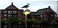
Belfast City Centre - Seagull on a Light
View is to the northeast from the west bank of the River Lagan towards Laganview Court Housing along the east bank of the River Lagan.
Image: © Joseph Mischyshyn
Taken: 23 Sep 2013
0.01 miles
2
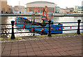
Dredging the River Lagan, Belfast - 2010/11 (108)
The crane barge at work very close to the Laganside walkway.
Image: © Albert Bridge
Taken: 18 Jan 2011
0.02 miles
3
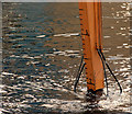
Dredging the River Lagan, Belfast - 2010/11 (109)
The crane barge’s jib, marked for depth, showing how far the bucket is under the surface. The published specification, GB003ZM6249, states “The Project involves the following: - The works shall involve the maintenance dredging of the impounded River Lagan to a level of -1.2m OD and the dredging and reinstatement of the 10m wide incised channel (to a depth of -2.5mOD).”
Image: © Albert Bridge
Taken: 18 Jan 2011
0.02 miles
4
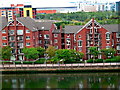
Housing along North Bank of River Lagan
View is to the northeast from Hilton Hotel Room #411.
Image: © Joseph Mischyshyn
Taken: 22 Sep 2013
0.02 miles
5
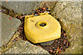
"Rain Bird" (USA) marker, Belfast
A yellow plastic object, marked “Rain Bird USA”, on the Lagan Walkway, near the railway bridge. At first glance it has the appearance of a survey mark http://www.geograph.org.uk/snippet/9133 but on looking more closely it seems to cover an access and might be part of the drainage system http://industrial.rainbird.com/index.htm.
Image: © Albert Bridge
Taken: 19 May 2014
0.02 miles
6
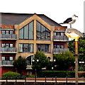
Belfast - City Centre - Sea Gull on Light Fixture
View is to the northeast from the west bank of the River Lagan where the bird is perched towards dwellings along the east bank.
Image: © Suzanne Mischyshyn
Taken: 23 Sep 2013
0.02 miles
7
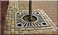
Tree protection, Belfast
The trees along the Laganside Walkway Image, between the Queen’s Bridge and the railway bridge, have this form of protection at ground level.
Image: © Albert Bridge
Taken: 6 Feb 2012
0.02 miles
8

Zapcats, Belfast (3 of 6)
Heading downstream, on a lap, after the sharp turn to port, before the railway bridge.
Image: © Albert Bridge
Taken: 6 Jun 2010
0.02 miles
9

Zapcats, Belfast (4 of 6)
Partly airborne, on a lap, after the sharp turn to port, downstream of the railway bridge.
Image: © Albert Bridge
Taken: 6 Jun 2010
0.02 miles
10

Zapcats, Belfast (5 of 6)
Close together, heading towards the Queen’s Bridge, downstream of the railway bridge.
Image: © Albert Bridge
Taken: 6 Jun 2010
0.02 miles